
Where is Chefchaouen in Morocco? The Ultimate Local Guide to the Blue Pearl of the Rif Mountains
When travelers plan a trip to Morocco, the striking blue-washed alleys of Chefchaouen are almost always at the top of their bucket list. However, many visitors do not realize exactly where it sits on the map until they begin planning their transportation.
To answer the core question directly: Chefchaouen is located in northwestern Morocco, tucked securely inside the western peaks of the Rif Mountain range.
Administratively, it serves as the capital of the Chefchaouen Province within the Tangier-Tetouan-Al Hoceima region.
Table of Contents: Where is Chefchaouen?
Understanding the Altitude and Landscape
Unlike the flat coastal plains or the wide expanses of the southern desert, Chefchaouen is a true mountain town:
-
The Elevation: The historic medina sits at an altitude of approximately 600 meters (nearly 2,000 feet) above sea level.
-
The Meaning Behind the Name: The word Chefchaouen comes from the native Amazigh language, translating locally to “look at the horns.” This is a direct reference to the twin, horn-shaped mountain peaks of Jbel Tissouka and Jbel Lakraa that tower dramatically right above the town.
Because it is built directly onto a steep, southwest-facing mountainside, the geography here shapes your entire experience. There are no cars inside the old historic center; the slopes are so vertical that the entire pedestrian medina relies on stone staircases, winding alleys, and traditional pack animals for moving goods.
Proximity to Major Northern Cities and Real Travel Times
To properly map out your route to Chefchaouen, you need to understand where it sits in relation to Morocco’s main northern entry points. Because it is surrounded by the rugged peaks of the Rif Mountains, it does not sit on a high-speed train line or a major flat highway network.
Here is the realistic geographic layout and driving distance from the most common starting cities:
-
From Tangier (The Closest Gateway): Chefchaouen sits roughly 115 kilometers (71 miles) southeast of Tangier.
-
From Tetouan: It sits 65 kilometers (40 miles) south of this historic Mediterranean city.
-
From Fes: It is located about 200 kilometers (124 miles) north of Fes, serving as the natural connection between the spiritual center of the country and the northern coast.
The Reality on the Ground: Mountain Driving Conditions
Many travelers look at a digital map and assume a 115-kilometer drive from Tangier will take a little over an hour. Here is the local insight that standard map apps won’t tell you about our terrain:
The Mountain Road Reality: Reaching Chefchaouen requires navigating winding, single-lane mountain passes that snake through the Rif range. The roads climb steadily, dealing with tight curves, occasional heavy mist, and slow-moving local transport trucks. Because of these geographical hurdles, you must budget your time realistically:
Tangier to Chefchaouen: Expect a 2.5 to 3-hour drive, depending on traffic and weather.
Fes to Chefchaouen: Expect a 3.5 to 4-hour drive across undulating, rural mountain terrain.
Understanding these travel times is vital for a smooth itinerary. The journey to the Blue Pearl is beautiful, taking you past limestone cliffs and green mountain valleys, but it requires a slow, careful pace.
Transportation Logistics: Navigating the Mountain Routes
Because Chefchaouen sits high in the Rif Mountains, you cannot book a direct train ride here. The high-speed Al Boraq train stops at the coast in Tangier. To bridge the geographic gap between the major low-altitude hubs and the mountain terrain, travelers must utilize the local road network.
Depending on your travel style and budget, there are three primary ways to navigate the roads up to the Blue Pearl:
-
1. National Bus Lines (CTM & Supratours): The most reliable public transport option is booking a ticket with a national carrier like CTM. Comfortable, air-conditioned coaches depart multiple times daily from Tangier, Fes, and Tetouan, pulling right into the Chefchaouen bus terminal. Tickets are highly affordable, usually costing around 80 to 100 MAD ($8 – $10 USD) from Tangier.
-
2. The Grand Taxi System (Shared or Private): These are larger intercity vehicles (often 6-passenger vehicles or vans) that run fixed routes across the mountains. You can head to a city’s designated grand taxi lot and buy a single seat in a shared taxi to Chefchaouen for roughly 70 MAD. Alternatively, if you prefer not to wait for the vehicle to fill up with other passengers, you can pay for all the seats upfront to secure a private, direct transfer.
-
3. Private Agency Transfers: For travelers who value maximum comfort, safety, and seamless logistics, hiring a private driver through a local agency is the premier choice. A private vehicle meets you directly at your airport, hotel, or ferry port, handling the mountain curves smoothly and allowing you to stop for scenic mountain vistas whenever you please.
Local Transit Insight: Preventing Motion Sickness
The physical geography of the Rif region creates specific challenges that surprise many first-time visitors who are used to smooth, flat highways:
The Winding Road Effect: The last hour of the drive approaching Chefchaouen involves non-stop tight turns, steep climbs, and sudden drops in altitude. If you are someone who is even mildly prone to motion sickness, it is highly recommended to pack appropriate medication ahead of time. Additionally, if you are traveling by bus, booking a seat closer to the front of the cabin will significantly reduce the swaying feeling caused by the sharp mountain switchbacks.

Weather & Climate: The Alpine Environment of the Rif Mountains
Because Chefchaouen sits at a much higher elevation than Morocco’s coastal cities or the southern plains, its weather pattern is entirely dictated by its alpine mountain geography. Many travelers arrive dressed for a tropical desert, completely unaware that the northern mountains experience a crisp, Mediterranean-alpine climate.
Here is what to expect across the seasons based on the town’s unique topography:
-
Spring and Autumn (The Ideal Windows): From April to May and September to October, the mountain air is perfectly balanced. Daytime temperatures hover comfortably around 20°C to 25°C (68°F to 77°F), creating ideal conditions for climbing the steep, vertical stairs of the medina or trekking in the nearby national parks.
-
The High Summer Peak: July and August bring intense heat, with temperatures occasionally climbing above 35°C (95°F). However, because of the mountain altitude, the air remains completely dry, and the moment the sun drops behind the limestone peaks of the Jbel Tissouka, the temperature drops rapidly into a refreshing evening breeze.
-
The Wet and Cold Winter: From November through February, the geography shifts completely. The Rif range receives heavy rainfall, dense mountain fog, and freezing temperatures that can plunge to 5°C (41°F) or lower at night. Snow is a regular sight on the higher mountain peaks surrounding the town.
Local Insight: The Microclimate of the Medina
The way Chefchaouen is built directly into the mountain slopes creates a highly localized weather experience inside the town itself:
The Shade and Stone Effect: The winding alleys of the historic medina are purposefully narrow and flanked by high stone houses to block out the intense midday sun. While this is a blessing in the middle of a hot July afternoon, it means that during the late autumn and winter months, the sun rarely hits the floor of the lower streets. The damp mountain air clings to the stone, making the shaded alleys feel significantly colder than open, sunny squares like Plaza Uta el-Hammam.
If you are visiting outside of summer, a heavy fleece, water-resistant layers, and high-traction shoes are absolutely essential to handle the chilly, mist-slicked stone steps safely.
The Geography of the Blue Color & The Ras El Maa Spring
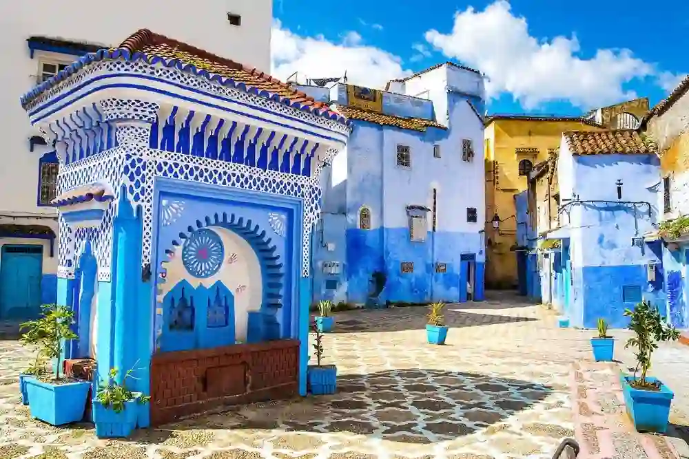
When talking about where Chefchaouen is, you cannot separate its physical location from its legendary appearance. The famous blue wash that covers the walls, doors, stairs, and even the pathways of the medina is directly tied to the town’s historical geography and natural resources.
While the town was originally founded as a fortress in 1471 to guard the mountains against northern invasions, it quickly became a sanctuary for Sephardic Jewish and Moorish refugees fleeing Spain. It was these community traditions that introduced the use of blue whitewash—historically used to mirror the sky and serve as a spiritual reminder of the divine.
The Lifeline of the Mountain: Ras El Maa
The physical layout of Chefchaouen is completely dependent on a single, vital geographic feature located on the eastern edge of the medina: the Ras El Maa spring.
-
The Fresh Mountain Source: Literally translating to “Head of the Water,” Ras El Maa is the exact point where fresh, ice-cold mountain water gushes directly out of the limestone cliffs of the Rif range.
-
The Flowing Network: Because the town is built on a steep slope, the natural gravity allows this fresh mountain water to flow effortlessly down through a historical network of channels, supplying the entire medina with fresh drinking water, feeding the public fountains, and powering the historic watermills.

Local Insight: The Living Culture of the Riverbanks
Ras El Maa is not just a landmark on a map; it is the beating heart of the town’s local community life:
The Mountain Laundry Ritual: If you follow the steep alleys all the way to the eastern edge of the town, you will cross a stone bridge over the rushing mountain stream. Here, you will still see local women gathering at the traditional stone washing troughs, chatting and washing rugs and clothes in the crisp mountain water just as their ancestors did centuries ago.
This abundant fresh water supply is also exactly why the mountain slopes surrounding Chefchaouen are so lush, green, and filled with fruit orchards—creating a striking natural contrast to the deep blue stone walls of the town.
Beyond the Blue: Talassemtane National Park and Surrounding Wilderness
Chefchaouen is world-famous for its blue urban landscape, but its physical location also makes it the ultimate basecamp for outdoor adventure in northern Morocco. The town sits immediately adjacent to Talassemia National Park (Tassemtane), a massive protected area spanning over 580 square kilometers of the Rif Mountain range.
This unique geographical positioning allows travelers to step directly out of a medieval medina and, within minutes, find themselves walking along rugged limestone peaks, deep river gorges, and dense forests.
Key Geographical Highlights of the Surrounding Wilderness
The terrain surrounding the town features some of the most striking and untouched natural landscapes in the Mediterranean basin:
-
The Rare Fir Forests: Talassemtane is home to the last remaining stands of the endangered Moroccan Fir (Abies maroccana), which cover the high-altitude peaks of Jbel Tissouka and Jbel Lakraa just above the town.
-
Akchour Gorge and God’s Bridge: Located about 30 kilometers (18 miles) from the center of Chefchaouen, the Akchour area is a dramatic river canyon. The most famous geographic feature here is Pont de Dieu (God’s Bridge), a massive, completely natural limestone arch that stands 25 meters above the rushing river below.
-
The Cascades of Akchour: A winding, river-side trail leads hikers past a series of crystal-clear emerald swimming holes, culminating in a towering natural waterfall tucked deep into the mountain rock faces.
Local Hiking Insight: The Spanish Mosque Overlook
You don’t need to embark on a multi-day backcountry expedition to appreciate how Chefchaouen blends into its mountain environment.
The Perfect Panoramic Vantage Point: For the best geographic perspective of the town, take the trail that exits the eastern gate at the Ras El Maa spring and winds up the opposite hillside to the isolated Spanish Mosque. Built on a prominent ridge in the 1930s, this vantage point offers an unobstructed view of the entire southwestern valley. From here, you can clearly see how the blue medina clings tightly to the massive limestone slopes, perfectly showcasing the dramatic terrain of the Rif range.
Integrating Chefchaouen into Your Morocco Itinerary
Now that you understand the unique geography and the mountain travel realities of the Rif range, the final step is knowing how to seamlessly position Chefchaouen into your broader Moroccan journey.
Because of its northern, high-altitude location, treating Chefchaouen as a quick day trip from distant southern cities is a major logistical mistake. Instead, it should serve as a scenic, relaxing bridge between the northern coast and the cultural heartland of the interior.
The Two Most Efficient Route Structures
To avoid spending unnecessary hours backtracking on winding mountain roads, local logistics experts recommend two primary itinerary flows:
-
The North-to-South Flow (The Gateway Route): If you are entering the country via the Tangier ferry port or airport, your optimal route drops straight down through the Rif range.
-
Tangier → Chefchaouen → Fes → Merzouga Desert.
-
This structure allows you to transition beautifully from the Mediterranean coast into the blue mountains, before descending into the imperial valleys.
-
-
The Imperial Loop (The Central Connection): If you are starting your trip further south in Casablanca or Rabat, Chefchaouen serves as the perfect northern loop before heading east or returning.
-
Casablanca → Rabat → Chefchaouen → Fes.
-
Local Planning Insight: How Long to Stay in the Blue Pearl
Because the town’s geographic footprint is relatively compact compared to sprawling cities like Fes or Marrakech, time management here is different:
The 2-Night Sweet Spot: Many budget day-trippers arrive at noon and leave by sunset, completely missing the true magic of the town. To truly experience Chefchaouen, we highly recommend staying for at least two nights. This gives you one full, unhurried day to explore the vertical steps of the blue medina in the quiet morning hours before tour buses arrive, and a second day to venture out into the surrounding Talassemtane National Park or Akchour Gorge.
By respecting the geography of the Rif Mountains and planning your transit carefully, your journey to the Blue Pearl will be a smooth, unforgettable highlight of your Moroccan adventure.

Conclusion: Step Into the Blue Pearl
Understanding exactly where Chefchaouen is in Morocco is the first step toward unlocking one of the most uniquely beautiful destinations on earth. Tucked away securely in the emerald peaks of the Rif Mountains, this town is far more than a stunning backdrop for photos, it is a living, breathing testament to history, resilience, and the peaceful “geography of silence” that defines Morocco’s high-altitude landscapes.
From the refreshing, ice-cold waters of the Ras El Maa spring to the steep, indigo-washed stone stairs of the ancient medina, Chefchaouen offers a rare chance to slow down, breathe fresh mountain air, and step into a completely different rhythm of life.
Pack Your Bags: The Adventure of a Lifetime Awaits!
If you have been hesitant about planning your trip, let this be your sign to take the leap. Morocco is a land of unmatched contrasts, where you can wake up to the cool mist of a northern mountain range and, within a few days, find yourself watching the sun set over the massive, golden sand dunes of the Sahara Desert.
Do not let the winding mountain roads or complex transit logistics hold you back. Navigating the peaks of the Rif range is simply part of the adventure, and the rewarding sight of the Blue Pearl emerging from the limestone cliffs makes every single switchback entirely worth it.
The locals are ready to welcome you with warm hospitality, fresh mint tea, and open arms. Stop staring at the maps, finalize your itinerary, and come experience the magic, the color, and the unforgettable landscapes of Morocco for yourself!

Your Local Experts
I’m Lahcen Saadi from the Exploring Morocco Trips team. We are local guides dedicated to crafting authentic and exceptional Moroccan experiences.
Whether you are planning your first trip to Morocco and need expert advice, or you are a travel professional looking to collaborate on unique itineraries, we are ready to help.
Plan Your Trip: Click any destination to see more
Best Morocco tours
- 3 Days Desert tour From Marrakech to Merzouga
- 3 Days Desert tour From Marrakech to Fes
- 3 Days Desert tour From Fes to Marrakech
- 4 Days Desert tour From Marrakech to Merzouga
- 4 Days Desert tour From Marrakech to Fes
- 4 Days Desert tour From Fes to Marrakech
- 5 Days Desert tour From Marrakech to Merzouga
- 5 Days Desert tour From Fes to Marrakech
Grand Morocco tours
- 7 Days Morocco tour from Marrakech
- 7 Days Morocco tour from Fes
- 7 Days Morocco tour from Casablanca
- 8 Days Morocco tour from Marrakech
- 8 Days Morocco tour from Casablanca
- 9 Days Morocco tour from Marrakech
- 9 Days Morocco tour from Casablanca
- 10 Days Morocco tour from Casablanca
- 12 Days Morocco tour from Casablanca
- 14 Days Morocco tour from Casablanca