
Where Is Rabat? Locating Morocco's Capital City on the Map
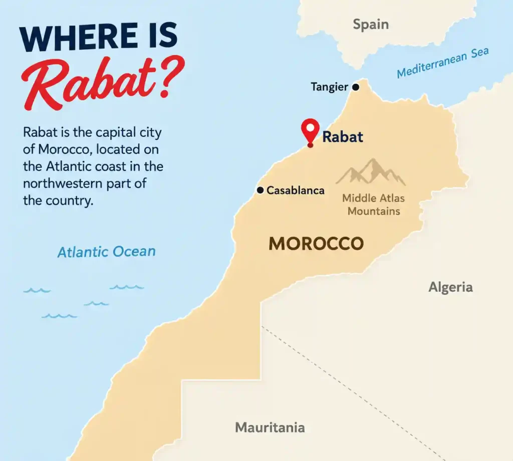
If you are building a Morocco itinerary, there’s a good chance Rabat isn’t the first city that comes to mind, Marrakech, Fes, and Casablanca tend to get most of the attention. But Rabat is actually Morocco’s capital, and understanding exactly where it sits on the map helps explain both its role in the country and how easily it fits into a wider trip. Here’s a clear answer to where Rabat is, what surrounds it, and how it connects to the rest of Morocco.
Table of Contents: Where is Rabat Located in Morocco
Rabat's Location at a Glance
Rabat sits on the northwestern coast of Morocco, right on the Atlantic Ocean, at the mouth of the Bou Regreg River. Its coordinates are approximately 34.02°N, 6.84°W, placing it in the northern half of the country, well north of Marrakech and roughly level with the northern stretch of Morocco’s Atlantic coastline. The Bou Regreg River separates Rabat from its sister city, Salé, on the opposite bank, and together the two cities form one of Morocco’s largest metropolitan areas.
Administratively, Rabat is the capital of the Rabat-Salé-Kénitra region, one of Morocco’s twelve administrative regions, and it functions as the country’s political and administrative center even though it isn’t Morocco’s largest or most internationally famous city.
How Rabat Relates to Morocco's Other Major Cities
Location makes a lot more sense with reference points, and Rabat sits conveniently close to several of Morocco’s other major cities along the northern coast.
- Casablanca is about 92 km (57 miles) south of Rabat, roughly an hour by car or train, making the two cities easy to combine on the same trip.
- Tangier sits about 280 km (174 miles) north of Rabat, along the same Atlantic coastline, roughly a 2.5 to 3-hour drive or a comfortable train ride.
- Fes lies inland to the east, around 200 km (125 miles) away, generally a 2.5 to 3-hour drive.
- Marrakech is considerably further south, roughly 330 km (205 miles) away, closer to a 3.5 to 4-hour drive or train journey.
This positions Rabat almost exactly between Casablanca and Tangier along the Atlantic coast, which is a big part of why it works so well as a stop on a north-to-south or coastal Morocco route.
Coastal, Not Inland: Rabat’s Geography
Unlike Fes or Marrakech, which sits inland, Rabat is a genuinely coastal city, and that shapes both its geography and its climate. The city stretches along the Atlantic shoreline, with sandy beaches, including the popular Plage de Rabat, right at the mouth of the Bou Regreg. The river itself is a defining feature of the city’s layout, curving between Rabat and Salé and opening directly into the ocean, which historically made the area a strategic natural harbor for trade.
Because of its position directly on the Atlantic, Rabat has a noticeably milder climate than inland cities like Fes or Marrakech, with a Mediterranean-influenced pattern of mild, wet winters and warm, dry summers rather than the more extreme inland temperature swings found further south or further from the coast.
Why Rabat, and Not Casablanca or Marrakech, Is the Capital
It’s a fair question, especially since Casablanca is larger and more economically prominent, and Marrakech and Fes carry more historical name recognition internationally. Rabat has actually been one of Morocco’s four imperial cities for centuries, founded in the 12th century by the Almohad ruler Abd al-Mu’min as a fortified base, but it only became the country’s political capital after Morocco’s independence in 1956. Its coastal location, historical significance, and role as an administrative center under the French protectorate all factored into that decision, and it’s remained the seat of government, foreign embassies, and the royal palace ever since.
Rabat's Layout: The Areas Worth Knowing
Understanding where Rabat is on a map is only half the picture, knowing how the city itself is arranged helps make sense of what you’ll actually encounter there.
- The Medina sits right on the coast, enclosed within a 12th-century fortified wall, with narrow streets and traditional markets closer in feel to Fes than to the polished boulevards found elsewhere in the city.
- The Kasbah des Oudaias perches on a cliff overlooking the Atlantic and the Bou Regreg River, a 17th-century fortress with an Andalusian garden and sweeping views across to Salé.
- The Ville Nouvelle (modern quarter) , built extensively during the French protectorate era, sits southwest of the medina and is home to government buildings, embassies, the national library, wide avenues, and most of the city’s cafés and boutiques.
- Chellah , just outside the city’s southeast corner, holds the ruins of an ancient Roman settlement and a later Merinid necropolis, a quiet, atmospheric spot that contrasts with the busier parts of the city.
Rabat's UNESCO World Heritage Status
Rabat’s location, layered with over 2,000 years of history, earned it UNESCO World Heritage status in 2012 under the title “Rabat, Modern Capital and Historic City: a Shared Heritage.” What makes the listing unusual is that it doesn’t celebrate a single ancient monument, it recognizes the entire city as a rare, well-preserved example of how a traditional Arab-Muslim city and an ambitious early 20th-century modern capital were woven together into one coherent whole. The inscribed area covers everything from the 12th-century Almohad ramparts and the unfinished Hassan Mosque to the Ville Nouvelle built by the French between 1912 and the 1930s, including its royal and administrative districts and the Jardins d’Essais botanical gardens. It’s considered one of the most complete and ambitious modern urban planning projects built anywhere in Africa during the 20th century.
Rabat's Long History, From Ancient Rome to Independence
Rabat’s location at the mouth of the Bou Regreg has attracted settlement for a very long time, well before Morocco existed in its current form. The area’s roots stretch back over 2,000 years, first as a Phoenician trading post and later the Roman settlement of Sala, whose ruins can still be visited today at Chellah. In the 12th century, the Almohad ruler Abd al-Mu’min transformed the site into a fortified ribat, a military base intended to support campaigns in Spain, laying the groundwork for the city that exists today. Centuries later, Rabat and its sister city Salé became known as a base for the “Republic of Salé,” associated with Barbary corsairs operating along the Atlantic coast in the 17th century. Rabat’s modern chapter began under the French Protectorate starting in 1912, when it was chosen as the administrative capital and rebuilt with wide boulevards and modern institutions, a status it kept permanently after Morocco’s independence in 1956.
Top Landmarks That Define Rabat's Skyline
A handful of sites capture what makes Rabat’s blend of old and new so distinctive, and most sit within easy walking or short taxi distance of each other.
- The Hassan Tower , the minaret of a mosque begun in 1184 and never completed, still stands as one of Rabat’s most recognizable landmarks, its rows of unfinished sandstone columns spread out across the site giving a sense of the scale originally planned.
- The Mausoleum of Mohammed V , built beside the Hassan Tower, houses the tombs of the king who led Morocco to independence and his sons, and is considered one of the finest examples of modern Alaouite architecture.
- The Kasbah des Oudaias , a 17th-century fortress on a cliff above the river, offers sweeping Atlantic views along with an Andalusian garden and a small museum of Moroccan art.
- Chellah , just outside the city walls compared, layers Roman ruins beneath a later Merinid-era necropolis, a quiet, atmospheric site that’s often overlooked to Rabat’s more famous stops.
Rabat vs. Casablanca: Two Very Different Neighbors
Given how close the two cities sit, just 92 km apart, it’s worth understanding how differently they feel once you’re actually there. Casablanca is Morocco’s largest city and commercial engine, dense, fast-paced, and built around business and industry. Rabat, by contrast, carries the quieter, more measured character of a government capital, wide tree-lined avenues, pale-stone ministries, and a noticeably calm pace of daily life. Rabat is also considerably less touristy than Casablanca’s Hassan II Mosque area or the medinas of Fes and Marrakech, which means fewer crowds, less pressure from vendors, and more room to explore at your own pace, something plenty of travelers who add it to their route come away pleasantly surprised by.
Getting to Rabat
Rabat’s central location on Morocco’s northern coast makes it genuinely easy to reach. Rabat-Salé Airport handles domestic and some regional flights, though many travelers arrive via Casablanca’s larger Mohammed V International Airport and continue to Rabat by train, a journey of under an hour. Morocco’s train network (ONCF) connects Rabat directly to Casablanca, Tangier, Fes, Meknes, and Marrakech, making it one of the easier Moroccan cities to reach without a car. If you’re driving, Rabat sits directly on the coastal highway connecting Tangier in the north to Casablanca, El Jadida, and Essaouira further south.
Frequently Asked Questions About Rabat's Location
Where exactly is Rabat located?
Rabat is on Morocco’s northwestern Atlantic coast, at the mouth of the Bou Regreg River, in the Rabat-Salé-Kénitra region of the country.
Is Rabat on the coast or inland?
Rabat is a coastal city, sitting directly on the Atlantic Ocean, unlike inland cities such as Fes or Marrakech.
How far is Rabat from Casablanca?
About 92 km (57 miles), roughly an hour by car or train.
How far is Rabat from Marrakech?
About 330 km (205 miles), typically a 3.5 to 4-hour drive or train journey.
Is Rabat close to Tangier?
Yes, relatively. Tangier is about 280 km (174 miles) north of Rabat along the same Atlantic coastline.
Why is Rabat the capital instead of Casablanca?
Despite Casablanca’s larger size and economic importance, Rabat was chosen as Morocco’s political capital after independence in 1956, building on its long history as one of Morocco’s four imperial cities and its role as an administrative center during the French protectorate.
Final Thoughts
Rabat sits in a genuinely convenient spot on Morocco’s map, right on the Atlantic coast, almost exactly between Casablanca and Tangier, and well connected by both road and rail to the rest of the country. That central, coastal location, combined with its role as Morocco’s political capital, makes it an easy and worthwhile addition to a wider Morocco itinerary rather than a detour out of the way.
If you are planning a Morocco trip and want help figuring out how Rabat fits into your route alongside cities like Fes, Marrakech, or a Sahara excursion, feel free to get in touch; we’re happy to help you plan a route that makes sense geographically and doesn’t waste time backtracking across the country.

I’m Lahcen Saadi from the Exploring Morocco Trips team. We are local guides dedicated to crafting authentic and exceptional Moroccan experiences.
Whether you are planning your first trip to Morocco and need expert advice, or you are a travel professional looking to collaborate on unique itineraries, we are ready to help.
- 2 Days Desert tours From Marrakech
- 3 Days Desert tour From Marrakech to Merzouga
- 3 Days Desert tour From Marrakech to Fes
- 4 Days Desert tour From Marrakech to Merzouga
- 4 Days Desert tour From Marrakech to Fes
- 5 Days Desert tour From Marrakech to Merzouga
- 5 Days Desert tour From Marrakech to Fes
- 6 Days Desert tour From Marrakech to Casablanca
- 7 Days Morocco tour from Marrakech
- 8 Days Morocco tour from Marrakech
- 8 Days Morocco tour from Marrakech with Imperial Cities
- 9 Days Morocco tour from Marrakech
- 10 Days Morocco tour from Marrakech
- 12 Days Morocco tour from Marrakech
- 14 Days Morocco tour from Marrakech
- 2 Days Desert tour From Fes to Merzouga
- 2 Days Desert tour From Fes to Marrakech
- 3 Days Desert tour From Fes to Merzouga
- 3 Days Desert tour From Fes to Marrakech
- 4 Days Desert tour From Fes to Marrakech
- 5 Days Desert tour From Fes to Marrakech
- 6 Days Desert tour From Fes to Marrakech
- 7 Days Morocco tour from Fes
- 4 Days Morocco tour from Casablanca
- 5 Days Morocco tour from Casablanca
- 6 Days Morocco tour from Casablanca
- 7 Days Morocco tour from Casablanca
- 8 Days Morocco tour from Casablanca
- 9 Days Morocco tour from Casablanca
- 10 Days Morocco tour from Casablanca
- 11 Days Morocco tour from Casablanca
- 12 Days Morocco tour from Casablanca
- 14 Days Morocco tour from Casablanca