How Far is Merzouga from Marrakech? The Ultimate Route and Distance Guide
If you are dreaming of the golden dunes of Erg Chebbi, one question likely dominates your itinerary: How far is Merzouga from Marrakech? This is not a simple highway commute; it is a cross-country expedition that traverses the High Atlas Mountains, the Anti-Atlas, and the vast Pre-Saharan steppes.
To help you plan your journey with precision, we have broken down every kilometer, every hour, and every route option available for this iconic Moroccan road trip.
Table of Contents: How Far is Merzouga from Marrakech
1. The Quick Answer: Essential Distance and Duration


For travelers looking for immediate figures to plug into their schedule, here is the baseline for the most common route (via Ouarzazate and Tinghir):
- Total Road Distance: 562 Kilometers (349 Miles)
- Net Driving Time: 9 to 10 hours (purely behind the wheel).
- Realistic Travel Time: 12 to 14 hours (including meals, fuel, and photo stops).
- Recommended Itinerary: 3 Days / 2 Nights to avoid exhaustion.
Key Distance Benchmarks (Cumulative from Marrakech)
- Marrakech to Tizi n’Tichka Pass: 100 km
- Marrakech to Ouarzazate: 195 km
- Marrakech to Dades Valley: 310 km
- Marrakech to Tinghir (Todra Gorge): 365 km
- Marrakech to Erfoud: 500 km
- Marrakech to Merzouga Dunes: 562 km
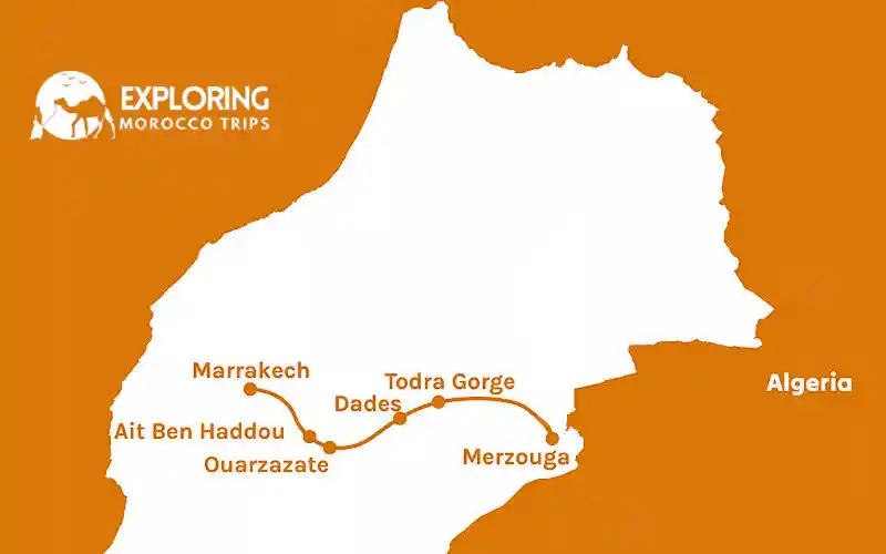
2. Route 1: The “Heritage & Gorges” Path (The Standard Route)
Distance: 562 km | Best For: First-time visitors and Photographers
This route follows the N9 and N10 national roads. It is widely considered the most scenic and culturally rich way to reach the Sahara.
Segment A: Marrakech to Ouarzazate (The Mountain Crossing)
This is the most challenging and visually stunning part of the drive. You leave the Haouz Plain and begin a steep ascent into the High Atlas.
- Distance: 195 km.
- Terrain: Winding mountain passes, sharp switchbacks, and high-altitude plateaus.
- Highlight: Tizi n’Tichka Pass. At 2,260 meters, this is the highest paved mountain pass in North Africa. The road offers panoramic views but requires focused driving due to ongoing safety improvements and sharp curves.
Segment B: Ouarzazate to Tinghir (The Valley of Roses)
Once you descend the mountains, the landscape shifts. The road flattens into the Dadès Valley, often called the “Road of a Thousand Kasbahs.”
- Distance: 170 km.
- Terrain: Semi-arid desert plateaus interspersed with lush green palm groves (Palmeraies).
- Highlight: Kelaat M’Gouna. This area is famous for its Damascus roses. In late spring, the entire valley is fragrant with blossoms.
Segment C: Tinghir to Merzouga (The Gateway to the Dunes)
The final stretch takes you through the “Black Desert” (Hammada).
- Distance: 197 km.
- Terrain: Flat, straight roads with occasional mirages. The orange sand dunes of Erg Chebbi will eventually appear like a golden wall on the horizon.
- Highlight: Erfoud and Rissani. These towns are the historic heart of the Tafilalet region and serve as the last major hubs for supplies before the desert camps.
3. Route 2: The “Ziz Valley” Highway (The Transit Route)
Distance: 550 km | Best For: Experienced drivers and those heading toward Fes later
This route stays further north for a longer period, utilizing the wider sections of the road near Errachidia.
- Marrakech to Ouarzazate: 195 km.
- Ouarzazate to Errachidia: 300 km (via the N10).
- Errachidia to Merzouga: 125 km (via the N13).
Why choose this? The drive through the Ziz Valley is breathtaking. You travel along the edge of a massive canyon filled with a “sea” of over 200,000 palm trees. While the total distance is similar to Route 1, the roads are generally straighter after Ouarzazate, allowing for a slightly higher average speed if you are in a hurry.
4. Why Does 560 km Take 10 Hours?
In many Western countries, 560 km would take about 5 or 6 hours on a motorway. In Morocco, it takes 10. Here is the reality of the road:
The “Tichka” Obstacle
The first 100 km out of Marrakech involves climbing over 2,000 meters in elevation. You will frequently be behind slow-moving heavy trucks and tour buses on narrow turns where overtaking is impossible. Safety must come before speed here.
Village Speed Limits
You will pass through dozens of small Berber villages. The speed limit drops to 60 km/h (and sometimes 40 km/h) without much warning. Radar checks by the Gendarmerie are very common, so drivers must adhere strictly to these limits to avoid fines.
The Landscape Distraction
This is perhaps the biggest factor. Between the Kasbah Ait Ben Haddou and the Todra Gorge, the scenery changes so dramatically that most travelers find themselves stopping every 30 minutes for a photo or a mint tea.
5. Critical Travel Time Factors
Weather and Seasonal Shifts
- Winter (Dec–Feb): Snow on the Tizi n’Tichka pass is a real possibility. While the government clears it quickly, it can lead to temporary delays or slower traffic.
- Spring (Mar–May): Occasional sand winds in the Tafilalet region can reduce visibility near Merzouga.
- Summer (June–Aug): Extreme heat in the desert plains means you must ensure your vehicle’s cooling system is in perfect condition.
Vehicle Performance
- Economy Car: Perfectly capable for the entire journey as the road is fully paved. However, it will climb the mountain passes more slowly.
- 4×4 SUV: Offers more comfort on the winding mountain roads and provides better suspension for the occasional pothole or gravel section.
- Public Bus (Supratours): The most budget-friendly option. The bus follows a strict schedule and makes designated stops for meals, usually taking about 12.5 hours to reach the Merzouga station.
6. Recommended Stopping Points to Break the Distance
To make the distance manageable and enjoyable, we recommend these logical breaks:
- The 2-Hour Mark (Taddert): A small village before the Tichka summit. It’s the best spot for a quick coffee and to stretch your legs before the final climb.
- The 4-Hour Mark (Ait Ben Haddou): Located just off the main road before Ouarzazate. This UNESCO site is a must-see. Give yourself at least an hour to explore.
- The 6-Hour Mark (Skoura): A lush oasis. If you are doing a multi-day trip, this is a serene place to spend your first night.
- The 8-Hour Mark (Tinghir): The last major city before the deep desert. It is the ideal place to refuel both your car and yourself.
7. Logistics: Fuel, Budget, and Costs
Estimated Fuel Expenses
Based on a round trip of roughly 1,120 km:
- Diesel Sedan: Expect to spend approximately 850–1,000 MAD on fuel.
- Petrol SUV: Expect to spend approximately 1,300–1,500 MAD.
- Expert Tip: Always keep your tank above half. While stations are frequent in towns, the stretches between Ouarzazate and Erfoud can be long.
Road Tolls
There are no major tolls on the national roads (N9/N10) between Marrakech and Merzouga. Your primary expenses will be fuel and occasional parking fees in towns like Ouarzazate or near the Gorges.
8. Distance Comparison Table
If your itinerary includes other Moroccan cities, use this table to plan your next leg:
| From Merzouga to: | Distance | Est. Drive Time |
| Fes | 470 km | 7–8 hours |
| Ouarzazate | 365 km | 5.5 hours |
| Agadir | 710 km | 11–12 hours |
| Casablanca | 660 km | 10 hours |
| Tangier | 780 km | 12–13 hours |
9. Frequently Asked Questions (FAQ)
How many hours of sunlight will I have for the drive?
Depending on the season, you have between 10 and 14 hours of daylight. In winter, the sun sets around 5:30 PM. Since the drive takes 10 hours, leaving Marrakech after 8:00 AM in winter means you will arrive in Merzouga in the dark, which we do not recommend.
Can I drive from Marrakech to Merzouga in a single day?
It is possible, but it is a grueling 10-hour drive that leaves no time for sightseeing. We strongly recommend stopping halfway (Dades or Ouarzazate) to experience the beauty of the route.
Is the road paved the entire way?
Yes. You will be on well-maintained national highways. You do not need a 4×4 to reach the village of Merzouga or the hotels at the edge of the dunes.
Is it safe to drive at night?
We advise against it. The High Atlas Mountains lack streetlights, and curves can be unpredictable. Additionally, it is common to encounter livestock or cyclists on the road in rural areas after dark.
What is the best time of day to leave Marrakech?
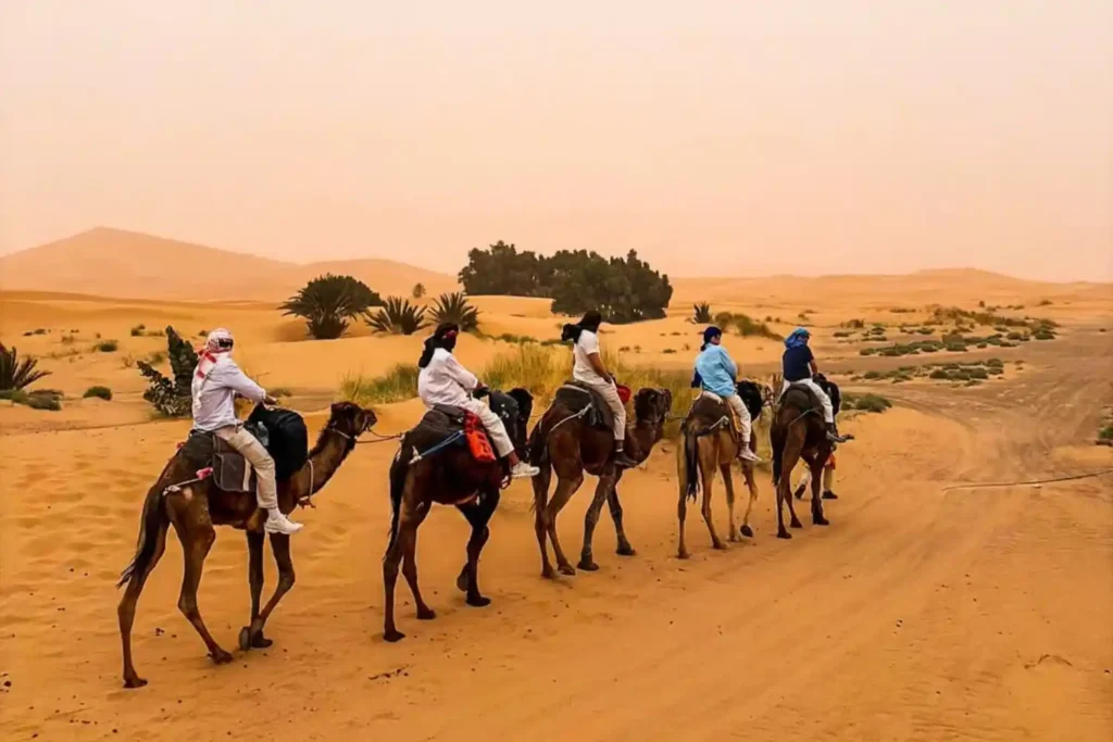
Aim for a 7:30 AM departure. This allows you to cross the mountains in the morning light and reach the desert in time for a sunset camel trek.
Are there many gas stations between Marrakech and Merzouga?
Yes, the route is well-serviced. You will find modern stations (Afriquia, Shell, Total) in Marrakech, Ouarzazate, Skoura, Boumalne Dades, Tinghir, and Erfoud. However, once you leave a major town, the stretches of empty road can be 50-80 km long. Always refuel when you hit half a tank.
Can I take a grand taxi from Marrakech to Merzouga?
You can, but it is expensive. A private grand taxi for this distance will cost between 1500 and 2500 MAD. You would usually hire the whole taxi. It is faster than the bus but less comfortable than a private tour vehicle.
Is there mobile phone signal during the 562 km drive?
For 90% of the route, yes. Major providers like Maroc Telecom and Orange have good coverage. However, you will lose signal in the deep canyons of the Tizi n’Tichka pass and inside the Todra Gorge. We recommend downloading “Offline Maps” on Google Maps before you leave Marrakech.
What is the Tizi n’Tichka pass road condition like right now?
The road is constantly being widened and improved. While most of it is smooth asphalt, there are several “work zones” where the road is gravel or dirt for short stretches. Expect construction vehicles and flagmen during daylight hours.
Is the tap water safe to drink at the stopping points?
We recommend sticking to bottled mineral water (like Sidi Ali or Ain Saiss) for the entire 562 km journey. It is widely available at every roadside cafe and small shop.
Do I need an International Driving Permit (IDP)?
Most car rental agencies in Marrakech accept a valid license from your home country (in English, French, or Spanish). However, having an IDP is always safer for police checkpoints along the national highways.
Are there many public toilets on the road?
Formal public toilets are rare. Most travelers use the facilities at cafes and gas stations where they stop for coffee or fuel. It is polite to buy a small item or leave a 2-5 MAD tip for the cleaning staff. Always carry your own tissues/toilet paper.
Can I see the Erg Chebbi dunes from the road?
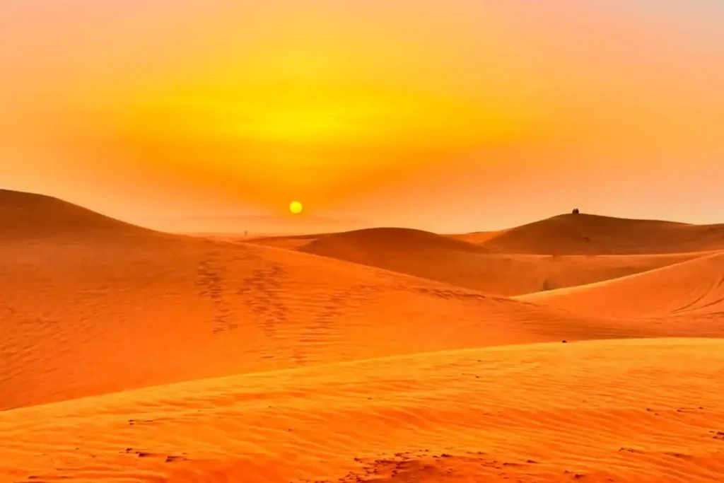
Not until the very end. You will drive through rocky plains for hours, and then, suddenly, about 20 km past Rissani, the high orange dunes of Merzouga will appear on the horizon. It is a dramatic and rewarding moment.
How much should I tip my driver if I book a private transfer?
For a multi-day trip covering this distance, a tip of 100-200 MAD per day for the group is standard and appreciated if the service was excellent.
What should I eat for lunch on the road?
The “Roadside Tajine” is a classic. Look for places with many locals or parked trucks, this usually means the meat is fresh. A “Berber Omelet” (cooked in a clay pot with tomatoes and onions) is a fast, delicious, and safe option for travelers.
Is the road to Merzouga prone to flooding?
During rare heavy rain (usually in Oct/Nov or Mar/Apr), “Oueds” (dry riverbeds) can flash flood and cross the road. If you see water flowing over the road, do not cross it. Wait for the water to recede or for local authorities to give the okay.
Can I use my credit card at gas stations?
In Marrakech and Ouarzazate, yes. In smaller villages and near Merzouga, many stations are “Cash Only.” Always carry enough Dirhams (MAD) to cover at least one full tank of fuel.
How far is Merzouga from the Algerian border?
Merzouga is very close to the border (about 50 km). You will see a military presence in some areas, but it is extremely safe for tourists. You cannot cross into Algeria here as the land border is closed.
Can I find vegetarian food during the drive?
Absolutely. Vegetable Tajines, lentils (L’aads), and fresh Moroccan salads are available at almost every roadside stop.
Are there pharmacies along the way?
Yes, every town has a “Pharmacie” marked with a green flashing cross. They are well-stocked and the pharmacists are very helpful.
What is the speed limit in Morocco?
On the open national roads (N9/N10), it is usually 80 km/h or 100 km/h. In villages, it is strictly 60 km/h. Be careful, police use laser guns and will stop you for going even 5 km over the limit.
Can I visit the Dades Gorges and Todra Gorges on the same day?
It is possible if you leave your hotel by 8:00 AM, but you will only have about 45 minutes at each spot. They are about 1.5 hours apart from each other.
Is it cold in the desert at night after the long drive?
Yes! Even if it was 35°C during your drive, the Sahara can drop to 5°C or even 0°C in winter nights. Bring a warm jacket, even in summer.
10. Conclusion: Why the Distance is Worth the Effort
The 562 km journey from Marrakech to Merzouga is the heart of the Moroccan adventure. While the driving hours are long, the transition from the bustling “Red City” to the silent, golden dunes of the Sahara is a visual masterpiece.
The secret to this trip is not in reaching the destination quickly, but in enjoying the stops along the way. Whether you are driving yourself or taking a private tour, the road to Merzouga is a legendary path that every traveler should experience at least once.