
Where is Marrakech? A Complete Guide to the City’s Location and Geography
If you are planning a trip to Morocco, one of the first questions you might ask is, “Where is Marrakech?” Understanding the location of this legendary city is the key to unlocking its secrets. Situated at the crossroads of ancient trade routes, Marrakech is much more than just a famous tourist destination; it is a geographic masterpiece where the snowy peaks of the High Atlas Mountains meet the warm gateway of the African desert.
Commonly known as the “Red City,” Marrakech owes its unique identity to the very ground it stands on. From its strategic position in the fertile Haouz Plain to its role as a central hub for exploring the rest of the country, the city’s geography has shaped its history, its climate, and its culture for nearly a thousand years.
In this complete guide, we will go beyond simple map coordinates. We will explore the hidden water systems beneath the streets, the logic behind the winding souks, and how the city’s physical layout continues to evolve today. Whether you are looking for travel logistics or the spiritual “Seven Saints” map, this guide will show you exactly where Marrakech sits in the heart and soul of Morocco.
Table of Contents about Marralech
The Exact Location of Marrakech
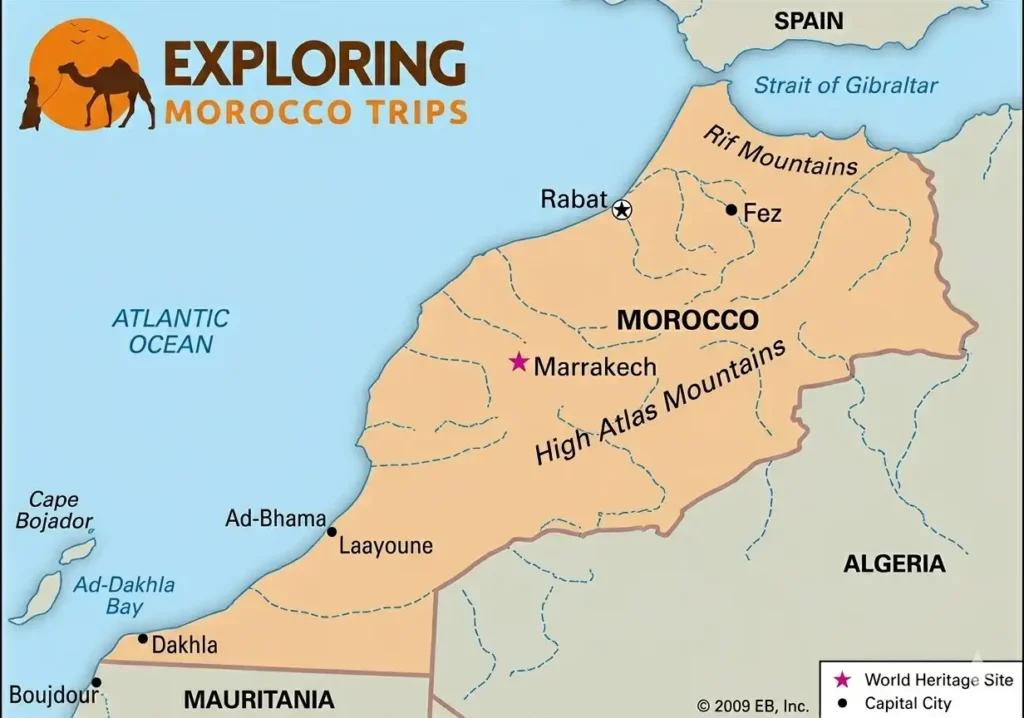
Marrakech is situated in the Haouz Plain, a fertile stretch of land in the west-central part of the country. Its coordinates place it roughly:
- Latitude: 31.6295 N
- Longitude: 7.9811 W
To the south, the skyline is dominated by the snow-capped peaks of the High Atlas Mountains, which act as a dramatic backdrop and a natural barrier separating the city from the Sahara Desert. To the w
Proximity to Major Hubs
Understanding where Marrakech sits relative to other Moroccan landmarks helps define its importance:
- Casablanca: About 240 km (150 miles) to the north, making Marrakech easily accessible via high-speed rail or highway.
- Rabat: The capital city lies roughly 320 km (200 miles) to the north.
- The Desert: While not in the Sahara itself, Marrakech is the primary launching point for expeditions into the Agafay Desert (stony desert) and the further dunes of Merzouga.
The Old City and the New City
To truly understand where Marrakech is, one must look at how the city is split between its ancient roots and its modern expansion. The city is essentially two worlds connected by long avenues of rose-colored walls.
The Medina: The Ancient Core
The “Old City” or Medina is a UNESCO World Heritage site and represents the historical soul of Marrakech. It is enclosed by 19 kilometers of massive ramparts (walls) built in the 12th century.
- The Hub: At the very center of this maze sits Jemaa el-Fnaa, one of the most famous public squares in the world.
- The Gates: Entry into this part of the city is through monumental stone gates known as Bab, such as Bab Agnaou or Bab Doukkala.
- The Atmosphere: Inside, the geography shifts into a dense network of narrow, winding alleys and souks (markets) where traditional navigation is based more on landmarks than street names.
Guéliz and Hivernage: The Modern Extension
Just outside the medieval walls lies the Ville Nouvelle (New City), primarily the districts of Guéliz and Hivernage. Established during the early 20th century, this area offers a sharp geographical contrast:
- Structure: Unlike the cramped alleys of the Medina, here you find wide boulevards, roundabouts, and French-style architecture.
- Lifestyle: This is where the city’s contemporary life thrives, featuring modern shopping centers, art galleries, and the famous Majorelle Garden.
The Green Belts
Marrakech is also defined by its “hidden” geography, the massive palm groves known as the Palmeraie. Located on the northern edge of the city, this oasis contains over 100,000 trees and serves as a natural buffer between the urban center and the surrounding plains.
The Weather in Marrakech
Because of its unique position between the High Atlas Mountains and the Sahara, the “where” of Marrakech is heavily defined by its weather patterns. It possesses a semi-arid climate, which creates a sharp contrast between seasons.
Seasonal Shifts
- The Summer Heat: From June to August, the city experiences intense heat. Its inland location means it lacks the cooling sea breezes of coastal cities like Casablanca. Temperatures often climb above 40°C, creating a dry, sun-drenched atmosphere.
- The Atlas Shield: During the winter (December to February), the nearby High Atlas Mountains are covered in snow. While the city remains mild and sunny during the day, averaging around 18°C to 20°C, the proximity to the mountains causes temperatures to drop significantly at night, sometimes reaching near freezing.
- The Golden Windows: Spring (March to May) and Autumn (September to November) are widely considered the ideal times to experience the city’s geography. The air is crisp, the gardens are in full bloom, and the mountain visibility is at its peak.
The “Chergui” Wind
Occasionally, Marrakech is visited by the Chergui, a hot, dry wind blowing in from the Sahara. This wind is a physical reminder of the city’s role as the “Frontier of the Desert,” bringing a sudden rise in temperature and a hazy, golden light that is a favorite for photographers.
Famous Places Near Marrakech
Beyond its own walls, the true power of Marrakech’s location lies in its role as a central “base camp.” Because of its unique position at the foot of the mountains and within reach of the coast, it serves as a geographic springboard for some of the most diverse landscapes in North Africa.
The Atlas Mountain Escape
Just an hour’s drive south, the terrain shifts from the flat Haouz Plain to the jagged peaks of the High Atlas.
- Ourika Valley: The closest escape for those looking to swap the city heat for cool mountain streams and terraced Berber villages.
- Imlil: Often called the “Chamonix of Morocco,” this village is the primary starting point for trekkers aiming to summit Mount Toubkal, the highest peak in North Africa.
The Desert Frontiers
While the iconic orange dunes of the deep Sahara are a long journey away, Marrakech offers two distinct “desert” experiences based on its geography:
- Agafay Desert: Located only 40 kilometers from the city, this is a “stone desert.” It provides a lunar-like landscape of white dunes and rocky plateaus, perfect for a sunset dinner or quad biking without the 9-hour drive to the Sahara.
- The Gateway to Merzouga: For those with more time, Marrakech is the starting point for the famous “Route of the Kasbahs,” leading travelers over the Tizi n’Tichka pass toward the massive sand dunes of Erg Chebbi.
The Atlantic Connection
To the west, the landscape flattens out into argan-tree-dotted plains leading to the ocean. The coastal town of Essaouira is roughly 190 km away. This proximity allows travelers to experience a medieval desert city and a breezy Atlantic port within the same trip, a geographical variety that few other cities in the world can match.
How to Get to Marrakech
When people ask “where is Marrakech,” they aren’t just looking for a spot on a map; they are looking for how to get there. The city’s geographic location has been enhanced by modern infrastructure, making it one of the most accessible hubs in Africa.
Menara Airport: A Geographic Masterpiece
Located just 6 kilometers from the city center, Marrakech Menara Airport (RAK) is frequently cited as one of the most beautiful airport terminals in the world. Its location allows travelers to land and be at the steps of the Medina or in a luxury hotel in Guéliz within 15 to 20 minutes.
- International Reach: It acts as a primary bridge between Europe and Morocco, with direct flights from most major European capitals taking under 4 hours.
- The View from Above: Upon arrival, the descent offers a unique geographic perspective: you see the transition from the arid plains to the lush green palm groves, all framed by the massive Atlas wall.
The Rail and Road Network
Marrakech is the “end of the line” in the best possible way for the Moroccan rail system.
- ONCF Trains: The city is connected to the north via a robust train network. While the high-speed Al Boraq currently reaches Casablanca, the traditional rail lines from Marrakech already provide a seamless link to Rabat, Kenitra, and Tangier.
- Highway Connectivity: The A7 motorway connects the city directly to the coast and the north, ensuring that while Marrakech feels like a desert oasis, it is never isolated from the country’s industrial and political centers.
A Walkable Urban Geography
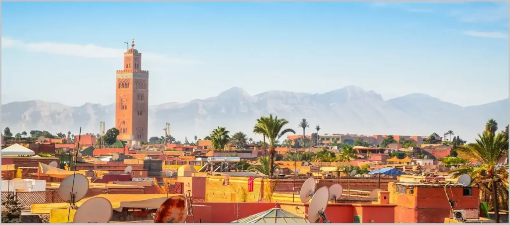
Despite its sprawl, the “tourist geography” of Marrakech is surprisingly compact. Most of the primary historical sites, like the Koutoubia Mosque, Saadian Tombs, and Bahia Palace, are located within walking distance of each other. This proximity is a deliberate result of how the city grew around its central mosque and palace districts over the centuries.
The Culture and People of Marrakech
To understand where Marrakech is geographically is to understand its role as a cultural melting pot. Its position has historically made it a “bridge” between Sub-Saharan Africa and the Mediterranean world. This unique placement has shaped a culture that doesn’t exist anywhere else in Morocco.
The Berber (Amazigh) Influence
Because Marrakech sits at the foot of the High Atlas, it is deeply influenced by the Berber heartland. Unlike the more Arab-influenced cities of the north, Marrakech’s pulse is tied to the mountain tribes. You see this in:
- The Language: While Darija (Moroccan Arabic) is the main tongue, the Shilha (Tachelhit) dialect is heard everywhere, reflecting the city’s role as the mountain people’s marketplace.
- The Crafts: The geography dictates the materials. The heavy wool rugs (Boucherouite and Beni Ourain) and the intricate silver jewelry found in the souks are products of the cold mountain winters and the rocky terrain of the south.
The Oasis Mentality
Marrakech exists because of an ancient and ingenious water management system called Khettara. These are underground tunnels that brought melted snow from the Atlas Mountains down to the dry plains.
- Hidden Water: Even though the city looks dry and dusty, its geography is actually defined by hidden water. This is why you find massive, lush gardens like the Agdal Gardens and the Menara Gardens in the middle of a semi-arid zone.
- The Riad Concept: This “interior geography” extends to the homes. The traditional Riad is designed to be a private oasis, with a courtyard and fountain at the center, mirroring the city’s larger struggle to create life in a harsh landscape.
A Gateway to the South
Historically, Marrakech was the last major stop for the great trans-Saharan caravans. Gold, salt, and spices traveled for months across the desert to reach the markets of the Red City. This “frontier” status gave the city an adventurous and somewhat mystical reputation that still draws travelers today. It isn’t just a city in the south; it is the Guardian of the South.
A Map Guide for Travelers
Knowing where Marrakech is on a map is one thing; navigating its physical layout is another. To help your readers transition from theory to reality, this section breaks down the city’s geography into practical zones that every visitor should recognize.
Understanding the “Districts”
While the city is vast, most travelers spend their time within three specific geographical pockets:
- The Kasbah: Located in the southern part of the Medina, this was the historical royal district. It’s slightly more spacious than the central souks and houses the Royal Palace. It feels like a “fortress within a city.”
- Mellah: This is the old Jewish Quarter, situated east of the Kasbah. Geographically, it is distinct for its architecture, featuring balconies that face the street, a rarity in the traditionally “inward-facing” design of Islamic architecture found elsewhere in the Medina.
- Sidi Ghanem: For those looking for the modern “Industrial Geography,” this district on the outskirts has become the hub for designers and artists. It’s where the city’s traditional craftsmanship meets contemporary international style.
The North-South Orientation Trick
Navigation in the Medina can be disorienting because the sun is often blocked by high walls. A professional tip for understanding where you are:
- The Koutoubia North Star: The minaret of the Koutoubia Mosque is the highest point in the city (by law, no building can be taller). If you are lost in the souks, look for the tower; it sits to the west of Jemaa el-Fnaa.
- Slope Awareness: The Medina actually has a very subtle slope. Generally, as you walk “downhill,” you are heading toward the northern gates (like Bab Doukkala); walking “uphill” usually leads you back toward the heart of the Kasbah and the palace areas.
The “Green Lungs” Perspective
To get a true sense of the city’s scale, one must look at the Agdal Gardens. Extending south from the Royal Palace, these gardens cover hundreds of acres. This massive green space is a reminder that Marrakech’s geography was designed to be self-sustaining, using its proximity to the mountains to feed vast orchards and olive groves that have survived for nearly a millennium.
The High Atlas Mountains

To truly grasp where Marrakech sits, one must look upward. The city’s identity is inseparable from the High Atlas mountain range, which creates a dramatic physical wall to the south. This isn’t just scenery; it is a massive geological barrier that dictates the city’s climate, water supply, and its connection to the rest of the continent.
The Tizi n’Tichka: The High-Altitude Gateway
If Marrakech is the heart of the region, the Tizi n’Tichka pass is its most vital artery. Reaching an elevation of $2,260$ meters ($7,415$ feet), it is the highest major mountain pass in North Africa.
- The Transition: As you leave the Marrakech plains and ascend this pass, the geography transforms from red dust and olive trees to rugged alpine peaks and ancient rock formations.
- The Divide: This pass is the precise point where the “Mediterranean” Morocco ends and the “Saharan” Morocco begins. Once you cross the summit, the air becomes significantly drier, and the landscape opens up into the vast, palm-fringed valleys of the pre-Sahara.
The Oued Tensift: The Life-Giving River
While the city often appears arid, its placement was originally chosen because of the Tensift River. Flowing to the north of the city, this river bed, though often dry on the surface during summer, represents the hidden hydrology of the region.
- Ancient Engineering: The city’s founders used the natural slope from the Atlas Mountains toward the Tensift to gravity-feed their gardens.
- Modern Impact: Today, the river basin defines the northern boundary of the city’s expansion, separating the urban center from the rugged hills of the Djebilet, a small range of ancient, weathered mountains that sit like a “crown” to the north of Marrakech.
The “Red Sandstone” Source
Even the very color of the city is a result of its specific location. The red earth used to make the millions of bricks for the Medina’s walls was sourced directly from the local clay deposits found in the surrounding Haouz Plain. Marrakech is quite literally a city built from the ground it stands on, making its architecture a physical extension of its own geography.
Lakes and Small Towns Near the City
While the city itself is a desert marvel, its geographic identity is anchored by a diverse rural belt that acts as its life-support system. Understanding the areas immediately surrounding Marrakech provides a complete picture of why this location was chosen nearly a thousand years ago.
The Lalla Takerkoust Reservoir
Roughly 40 kilometers southwest of the city lies a massive geographic anomaly: Lalla Takerkoust Lake. Created in the late 1920s by damming the Nfis River, this man-made lake covers over 5,000 hectares.
- The Contrast: It serves as a visual shock, a vast expanse of shimmering blue water surrounded by the red, sun-scorched earth of the Agafay plains.
- The Purpose: Beyond recreation, this lake is a critical piece of the regional geography, managing the water runoff from the High Atlas to ensure the Marrakech palm groves remain hydrated even during the driest months.
Tahnaout and the Foothill Transition
To the south, the town of Tahnaout marks the true geographic “step” into the mountains. As you drive toward it, the flat Haouz Plain suddenly gives way to rolling red hills and steep limestone cliffs.
- The Vegetation Shift: This is where the landscape changes from olive and palm trees to wild oak, juniper, and citrus orchards. The soil here is incredibly rich in minerals, which gives the surrounding hills an intense, deep-red hue that contrasts sharply with the green of the terraced Berber farms.
- The Gorge Geography: Tahnaout is the entry point to the Moulay Brahim Gorges, where the tectonic activity of millions of years has carved deep, narrow paths into the rock. These natural corridors are what allowed ancient trade routes to penetrate the “wall” of the Atlas Mountains.
The Jbilets: The “Little Mountains” of the North
While everyone looks south toward the Atlas, the northern geography is defined by the Jbilets. These are much older, more weathered mountains that look like low, jagged hills.
- A Lunar Landscape: The Jbilets are largely uninhabited and lack the lush valleys of the Atlas. They create a stark, lunar-like boundary that shields Marrakech from the harsher winds of the northern plains.
- The Sky View: Because they are lower in elevation and far from the city lights, the Jbilets offer the best “dark sky” geography near Marrakech, making them a prime spot for stargazing and hot-air ballooning.
How the City is Growing Today
Marrakech is no longer confined by its ancient walls or the French-built boulevards of the 1900s. The city’s geography is currently undergoing a massive outward expansion, driven by its status as a global tourism magnet and a growing center for international events.
The Rise of the “New” West and Chrifia
As the city pushes southwest along the roads leading toward the Agafay Desert, new districts like Chrifia have emerged. This area represents a shift in the city’s residential geography:
- The Transformation: What was once open scrubland is now home to large-scale golf resorts, water parks, and ecological luxury villas.
- Sustainability Challenges: This expansion is forcing the city to rethink its geographic relationship with water. Modern developments here are increasingly utilizing treated wastewater for their vast green spaces, reflecting a move toward “smart geography” in the face of a changing climate.
The Northern Expansion and Targa
To the northwest, the district of Targa has become the primary suburban hub for the city’s growing middle class. Unlike the dense, vertical apartments of Guéliz, Targa is defined by low-rise villas and wider streets.
- A Natural Buffer: This area sits between the historic center and the industrial zones, acting as a residential bridge. It is one of the few places in Marrakech where the city’s urban heat island effect is slightly mitigated by the increased canopy of private gardens.
The “Sidi Abdellah Ghiat” Corridor
Looking toward the southeast, the geography is becoming dominated by what locals call the “Route de l’Ourika.” The land between Marrakech and the village of Sidi Abdellah Ghiat is rapidly transitioning from traditional farmland to “rurban” space.
- The Appeal: Investors are drawn to this specific geographic corridor because it offers the most unobstructed views of the High Atlas peaks.
- Future Planning: Urban planners are currently focusing on this area to ensure that the city’s growth doesn’t swallow the very natural beauty that attracts visitors. This includes preserving “green corridors” that allow the mountain air to flow into the city’s core.
The Smart City Vision: Tamansourt
Roughly 15 kilometers outside the city center, the “satellite city” of Tamansourt was founded to relieve the geographic pressure on Marrakech. Designed as a standalone urban center, it reflects a modern attempt to decentralize the “Red City,” creating a new geographic pole that balances the weight of the ancient Medina.
Inside the Small Streets (The Derbs)
To understand where Marrakech is, one must eventually look at the smallest unit of its geography: the Derb. While the Medina is often described as a single maze, it is actually a collection of hundreds of these tiny, dead-end alleys that function like private villages within the city walls.
The Architecture of Privacy
The geography of a Derb is a masterclass in ancient social engineering.
- The Inward Focus: Unlike Western cities where windows and balconies face the street, the Derb is defined by high, windowless walls. This creates a “silent geography” where the outside world is intentionally kept at bay to preserve the cool air and the privacy of the family.
- The “Sabbe” (Covered Alleys): You will often find parts of the Derb that are built over, creating cool, dark tunnels known as Sabbe. These aren’t just for shade; they are structural bridges that connect houses on opposite sides of the alley, maximizing living space in a crowded urban environment.
The Sensory Micro-Climate
Each Derb has its own unique atmospheric signature.
- The Soundscape: Because the walls are so thick and the streets so narrow, the roar of the city’s motorbikes often vanishes the moment you turn into a residential Derb. It is replaced by the “internal” sounds of Marrakech: the rhythmic thud of a weaver’s loom, the splashing of a communal fountain, or the distant echoes of children playing.
- Light and Shadow: The geography of the Medina creates a “canyon effect.” During the day, only a thin sliver of sunlight reaches the ground, moving like a clock across the ochre walls. This isn’t accidental; it’s a natural cooling system that keeps the ground level significantly cooler than the rooftops.
The Five Pillars of the Neighborhood
Traditionally, every cluster of Derbs was designed to be geographically self-sufficient. To be a “true” neighborhood, a section of the city had to have five specific things within walking distance:
- The Mosque: The spiritual center.
- The Madrasa: The school for the children.
- The Hammam: The public bathhouse (essential since individual houses didn’t traditionally have running hot water).
- The Hanout: The tiny local grocery store.
- The Fernatchi: The communal bakery oven, which also provides the heat for the local hammam.
This “five-pillar” geography ensured that even if the city gates were closed, life within the neighborhood could continue uninterrupted.
The View from the Rooftops
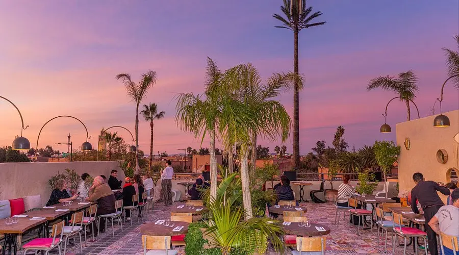
While the streets of Marrakech are defined by the dense, earthy red of the Medina walls, there is an entire second city that exists just a few meters above. The “Rooftop Geography” of Marrakech is perhaps the city’s most vital social and architectural layer, providing a necessary escape from the intensity of the ground-level souks.
The “Second Floor” Culture
In Marrakech, height is a luxury. Because the city is built on a flat plain, even rising just ten or fifteen meters provides a massive shift in perspective.
- The Cooling Effect: As you move from the narrow alleys to the terraces, you leave behind the trapped heat of the stone streets. The rooftops catch the “Atlas Breeze,” a cooling airflow that descends from the mountains every afternoon.
- The Visual Horizon: From above, the chaotic “Red City” suddenly becomes organized. You can see the grid of the city’s minarets, the hidden inner courtyards of the Riads, and the storks nesting on the ancient ramparts of the El Badi Palace.
A Different Soundscape
The acoustics of the rooftops are completely different from the streets below. At ground level, you hear the immediate, the haggling of merchants and the roar of scooters. On the rooftop, the soundscape is dominated by the Adhan (call to prayer). Because the rooftops are level with many of the city’s minarets, the sound of the call to prayer travels across the flat rooflines, creating a hauntingly beautiful surround-sound effect that defines the city’s spiritual atmosphere.
The Evolution of the Terrace
Historically, the rooftops were the domain of women, used for drying laundry, preparing sun-dried vegetables, or socializing away from the public eye. Today, this geography has evolved into a global design trend.
Sunset Geography: There is a specific “Golden Hour” geography in Marrakech. As the sun dips toward the Atlantic, the orange-red walls of the city seem to glow from within. This is the moment when the city’s rooftop restaurants and lounges become the busiest, as everyone seeks a front-row seat to watch the High Atlas mountains turn purple against a burning pink sky.
The Modern Oasis: Many of the city’s most famous “secret” locations are found here. Terraces like those at Le Jardin Secret or the iconic cafes surrounding the Spice Square (Rahba Kedima) have transformed the rooftops into lush, hanging gardens.
The Seven Saints of Marrakech

Marrakech is not just a collection of buildings and markets; it is geographically anchored by its spiritual history. To the local people, the city is known as “Sabaatou Rijal” or the “Seven Saints.” The placement of the shrines (Zaouias) dedicated to these men creates a sacred map that many pilgrims follow to this day.
The “Seven Saints” Protectorate
The concept of the Seven Saints was established by the 17th-century scholar Al-Yusi under the order of the Sultan. The goal was to create a spiritual perimeter around the city. These shrines are located throughout the Medina, and their presence has influenced how the city grew:
- Sidi Bel Abbas: Located near the northern gate of Bab Taghzout, his shrine is the most famous. The area around it has historically been a hub for the poor and the blind, as he was the patron saint of charity. This specific geographic pocket remains one of the most culturally traditional parts of the city.
- Sidi Ben Slimane Al-Jazuli: Situated in the northern Medina, his shrine is a masterpiece of Moroccan architecture. The presence of such a holy site preserved the surrounding neighborhood, keeping it as a quiet residential enclave even as tourism grew elsewhere.
- Sidi Abdellah el-Ghazouani: Located near the Mousshine Mosque, this saint is often associated with the fertility of the land. His location reflects the city’s deep connection to the Haouz Plain and the agricultural wealth of the region.
The Ritual of the “Ziara”
There is a specific geographic order to visiting these saints. Traditionally, pilgrims would enter through one gate and walk the city in a counter-clockwise circle. This “Spiritual Walk” takes you through the entire landscape of the Medina:
- You start in the southeast.
- You move through the dense central markets.
- You end in the quiet, residential north. By following this path, one experiences the full diversity of Marrakech’s urban geography, from the royal power centers to the humble artisan quarters.
The Architecture of the Shrines
Geographically, the shrines are easy to spot from the rooftops. While most houses have flat roofs, the shrines often feature green-tiled pyramidal roofs. Green is the color of Islam and paradise, and these emerald-colored points across the cityscape act as landmarks. They serve as “quiet zones” within the busy geography; even if the streets outside are chaotic, the space inside the Zaouia is a sanctuary of silence, fountains, and shade.
The Underground Water Secret: How the City Stays Green
When you look at where Marrakech is on a map, it seems impossible that so many gardens and palm trees can survive in such a dry, hot location. The secret to the city’s geography is not what you see on the surface, but what is hidden underground.
The Ancient “Khettara” System
Hundreds of years ago, the people of Marrakech created an incredible engineering system called the Khettara. These are long, underground tunnels that travel for miles.
- The Source: These tunnels start at the base of the High Atlas Mountains, where they collect water from melted snow.
- Gravity Power: Because the mountains are higher than the city, the water flows naturally through these tunnels without needing pumps or electricity.
- Protection from Heat: By keeping the water deep underground, it doesn’t evaporate in the 40°C summer sun. This is the only reason Marrakech was able to become a large city in the middle of a dry plain.
The Resulting Green Oasis
This hidden water geography created the famous Palmeraie (Palm Grove). If you look at the city from above, you will see a massive green belt on the northern side. This isn’t just for decoration; it was a functional agricultural zone that provided food and shade for the city.
- The Agdal and Menara: These are two massive historical gardens with huge water basins. They act like giant batteries, storing the water that comes from the mountains so it can be used to water the olive trees and orchards during the driest months.
A Modern Challenge
Today, as the city grows, this ancient “water geography” is changing. The city is now using modern pipes and recycling water to keep its famous gardens green. However, the old tunnels are still there beneath the ground, a reminder that the location of Marrakech was chosen specifically because of its relationship with the water from the mountains.
The Market Geography: How the Souks are Organized
One of the most fascinating things about where Marrakech is located is how it functions as a giant, organized machine. To a visitor, the markets (Souks) look like a chaotic maze, but they actually follow a very strict geographic logic. For centuries, the city’s trade has been divided into specific zones based on the materials and the noise level of the crafts.
The Center of the Circle
The most valuable and “clean” items are always located closest to the Koutoubia Mosque and the center of the Medina.
- The Souk Smarine: This is the main artery of the market geography. It is wide and covered, and it serves as the entry point for textiles and high-end clothing.
- The Spice Square (Rahba Kedima): This is a geographic “breathing space” in the middle of the dense alleys. It was placed here to allow for the trading of herbs, spices, and traditional medicines in an open, sunlit area.
Moving Toward the Outer Walls
As you walk further away from the center, the geography of the shops changes. The “noisy” or “smelly” trades were traditionally pushed toward the city gates (Babs).
- The Blacksmiths (Souk Haddadine): You will find these near the edges of the central areas because of the fire and the loud hammering.
- The Tanners (Les Tanneries): These are located at the very eastern edge of the Medina, near Bab Debbagh. This was a strategic geographic choice; they needed to be near the river for water, but far enough away from the residential areas so the smell of the leather tanning wouldn’t disturb the citizens.
The “Souk” as a Social Map
Every trade has its own street. There is a street just for slippers (Babouche), a street for brass lamps, and a street for woodcarvers. This layout wasn’t just for tourists; it was designed so that master craftsmen could keep an eye on the quality of their neighbors’ work. When you understand this “trade geography,” you realize that the city is actually a perfectly organized library of Moroccan craftsmanship, where every item has its own specific neighborhood.
The Royal Geography: The Evolution of Power Centers
To fully grasp the layout of Marrakech, one must look at the Royal Geography. Since its founding, the city has been the seat of several dynasties, and each one left a physical mark on the map. These palaces were not placed randomly; they were built to show strength and control over the city’s most important resources.
The Kasbah: A City Within a City
Located in the southern part of the Medina, the Kasbah is a distinct geographic zone. It was built as a secure fortress for the Sultan and his administration.
- The Design: It is separated from the main public markets by massive walls and its own monumental gates, like Bab Agnaou.
- The Royal Palace (Dar el-Makhzen): This is a huge area that remains a working royal residence today. Its presence in the south creates a “quiet zone” of high security, which keeps the southern part of the Medina much calmer than the busy northern souks.
The Ruins of Grandeur: El Badi Palace
The geography of the 16th century is best seen at the El Badi Palace. When it was built, it was one of the largest structures in Africa.
- The Layout: It was designed with massive sunken gardens and giant pools to symbolize paradise.
- The Modern Resident: Today, the geography of this palace has been taken over by nature. The tops of its crumbling orange walls have become the primary nesting grounds for white storks, which are now a famous part of the city’s skyline.
The Bahia Palace: The Art of Space
Further north, the Bahia Palace represents a shift in how power was shown in the 19th century. Instead of a massive fortress, it is a sprawling collection of courtyards and riads.
- The Hidden Logic: The palace was designed to be a “labyrinth of beauty.” As you walk through it, the geography intentionally confuses you to make the space feel much larger than it actually is.
- The Connection to the Medina: Unlike the isolated Kasbah, the Bahia Palace sits right against the edge of the Mellah (Jewish Quarter), showing how the royal administration was geographically linked to the city’s commercial and minority districts.
Frequently Asked Questions About Marrakech
To help you prepare for your trip and understand the unique layout of the city, I have put together a list of the most common questions travelers ask. These answers will help you navigate the “Red City” like a local and better understand the fascinating geography that makes this place so special.
Is Marrakech in the desert?
Technically, no. Marrakech is located on a flat plain (the Haouz Plain) at the foot of the mountains. However, the Agafay Desert (a stony desert) is only 40 minutes away, and the city has a very dry, desert-like atmosphere because it is far from the ocean.
How far is Marrakech from the Sahara?
The real sand dunes of the Sahara (like Merzouga) are quite far. You must cross the High Atlas Mountains, which usually takes about 8 to 9 hours by car. This is why many people visit the nearby Agafay Desert for a shorter experience.
What is the best way to get around the city?
Because the Medina is a maze of narrow streets, the best way to explore its geography is on foot. For longer distances to the New City (Guéliz), the small beige taxis (Petit Taxis) are the most common way to travel.
Can you see the ocean from Marrakech?
No, Marrakech is an inland city. The nearest coastal city is Essaouira, which is about 190 kilometers (118 miles) to the west. It takes about 2.5 to 3 hours to reach the Atlantic coast.
Why is the city called the “Red City”?
This is due to the local soil. The clay used to make the city’s walls and buildings is naturally red and ochre. By law, buildings in the city must maintain these earthy tones to protect the city’s historical identity.
What is the elevation of Marrakech?
Marrakech sits at an altitude of approximately 466 meters (1,529 feet) above sea level. This elevation is why the city stays relatively warm during the day but can feel quite fresh and cool once the sun goes down, especially compared to coastal cities.
Is Marrakech in Africa or the Middle East?
Marrakech is located in North Africa. While it shares many cultural, linguistic, and religious ties with the Middle East, its geography is strictly African. It is part of the Maghreb region, which is the western part of the Arab world.
Where is Marrakech located in relation to the Atlas Mountains?
The city is situated just north of the High Atlas Mountains. On a clear day, particularly in the winter and spring, you can see the snow-covered peaks from almost any rooftop in the city. The mountains are about a 45-minute to one-hour drive from the city center.
What is the nearest city to Marrakech?
The closest major urban neighbor is Settat to the north or Agadir to the southwest across the mountains. However, many small, culturally rich towns like Tahnaout and Amizmiz are much closer and serve as important local trading hubs for the city.
Does it ever snow in Marrakech?
Snow in the city center is extremely rare. While the mountains just 60 kilometers away are covered in deep snow for several months, the city itself almost never sees a snowflake. The last time significant snow was recorded in the city streets was several decades ago.
Is Marrakech a coastal city?
No, Marrakech is an inland city. It is surrounded by plains and mountains. If you want to visit the beach, you will need to travel west to cities like Essaouira or Safi, which takes about three hours.
Is Marrakech the capital of Morocco?
No, the capital of Morocco is Rabat, which is located on the coast. However, Marrakech is often considered the “tourist capital” or the “southern capital” because of its historical importance as a former imperial city and its huge role in the country’s economy.
Which language is spoken in Marrakech?
The most common language is Darija (Moroccan Arabic). Because of the city’s geography near the mountains, you will also hear Tachelhit (a Berber language). Most people working in tourism also speak French, and many speak English and Spanish fluently to help international travelers.
What is the “Haouz Plain”?
The Haouz Plain is the large, flat area of land where Marrakech was built. It is a very important agricultural region for Morocco. Because it sits at the foot of the Atlas Mountains, the soil is very rich, allowing the area to produce millions of olives, oranges, and almonds every year.
Is Marrakech safe for travelers to walk around?
Yes, Marrakech is generally very safe. The city’s geography is monitored by a special “Tourist Police” force that ensures visitors feel comfortable. While the Medina can be confusing, the local people are usually very helpful in pointing you back toward the main square or your hotel.
Why are there so many gardens in a dry city?
Gardens in Marrakech are more than just pretty spaces; they are a sign of life and wealth. Historically, having a garden meant you had mastered the geography of water. Today, places like the Majorelle Garden and Le Jardin Secret serve as “green lungs” that help clean the air and provide a cool escape from the city heat.
What time zone is Marrakech in?
Marrakech follows Western European Time (GMT+1) for most of the year. It is usually in the same time zone as London or Paris, making it very easy for European travelers to visit without experiencing jet lag.
What is the “Palm Grove” (Palmeraie) area?
The Palmeraie is a unique geographic zone on the northern edge of the city. It is a massive green oasis covering about 54 square miles. It contains over 100,000 palm trees that were originally planted centuries ago. Today, it is a luxury district known for its beautiful villas, camel rides, and golf courses, providing a quiet contrast to the busy Medina.
Are there rivers inside Marrakech?
The city does not have a large river flowing through the center. The Oued Tensift runs along the northern outskirts. While it often looks like a small stream during the dry summer, it becomes a powerful river during the rainy season when the snow melts in the Atlas Mountains. Most of the water used in the city travels through underground channels rather than open rivers.
Why is Jemaa el-Fnaa so important to the city’s layout?
Jemaa el-Fnaa is the geographic heart of Marrakech. Every major street in the Medina eventually leads back to this square. Historically, it served as the main meeting point for mountain tribes coming to trade with the city dwellers. Even today, it acts as the “bridge” between the old world of the souks and the modern entrance to the city.
Where is the best place to see the sunset in Marrakech?
Because Marrakech is located on a flat plain, the best places to see the sunset are the rooftop terraces in the Medina. From these high points, you have an unobstructed view of the sun dropping behind the Koutoubia Mosque, with the High Atlas Mountains turning shades of pink and purple in the distance.
How far is the Agafay Desert from Marrakech?
The Agafay Desert is located about 30 to 40 kilometers (25 miles) southwest of Marrakech. It is not a sand desert with dunes, but a “stone desert.” It is popular because its geographic location allows you to experience a desert-like landscape and beautiful camps in less than an hour’s drive from the city center.
Is Marrakech near the Atlas Film Studios?
No, the famous film studios are located in Ouarzazate. To get there from Marrakech, you must drive about 4 hours south and cross the Tizi n’Tichka pass. While Marrakech is the gateway to this region, the desert filming locations are on the other side of the mountain range.
Final Thoughts: Why the Geography of Marrakech Matters
Understanding where Marrakech is provides more than just a sense of direction; it offers a deeper connection to the soul of Morocco. The city’s unique locatio, tucked between the protective wall of the High Atlas and the vast openness of the plains, is why it has remained a powerful center of trade and culture for centuries. Every red wall, hidden garden, and narrow alleyway is a physical response to the surrounding environment, proving that Marrakech is a city that lives in perfect harmony with its landscape.
Whether you are navigating the historic maze of the Medina or watching the sunset from a rooftop in Guéliz, the geography of the Red City is designed to inspire. It is a place where every corner tells a story of survival, artistry, and spiritual depth. Now that you know the map, it is time to experience the magic of this crossroads for yourself.
If you are ready to see the beauty of the Red City and beyond, there is no better way than with a local expert. For an unforgettable adventure from the mountains to the dunes, we recommend you book your trip with Exploring Morocco Trips. Let us show you the hidden side of Marrakech and the breathtaking landscapes that make this country truly unique.