
Where Are the Atlas Mountains? A Complete Guide to Africa’s Great Mountain Range
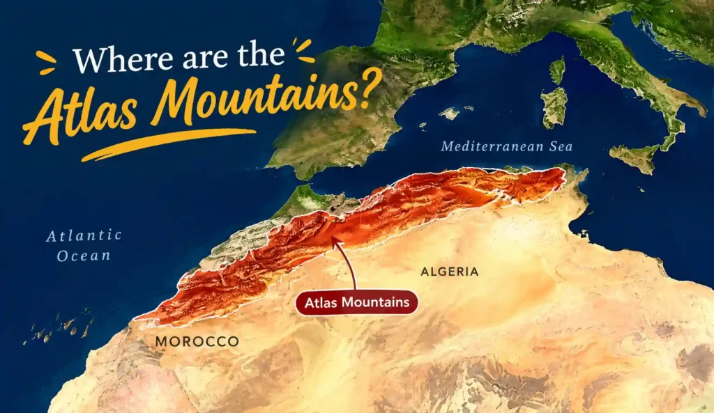
Ask most people to picture Morocco, and they will think of deserts and medinas long before they think of mountains, yet the Atlas Mountains are one of the most defining geographic features not just of Morocco, but of the entire northwestern corner of Africa. They stretch across three countries, hold North Africa’s highest peak, and physically separate the Mediterranean and Atlantic coastlines from the Sahara Desert. This guide breaks down exactly where they are, how they’re divided, and why they matter so much to a Morocco trip specifically.
Quick Facts About the Atlas Mountains
| Fact | Detail |
|---|---|
| Location | Northwest Africa, across Morocco, Algeria, and Tunisia |
| Total length | Approximately 2,500 km (1,600 miles) |
| Highest peak | Mount Toubkal, 4,167 m (13,671 ft), in Morocco’s High Atlas |
| Main subranges | Rif, Middle Atlas, High Atlas, Anti-Atlas (Morocco); Tell Atlas, Saharan Atlas, Aurès (Algeria/Tunisia) |
| Formation | Began roughly 80 million years ago via tectonic plate collision |
| Region | Part of the Maghreb |
| Role | Separates the Mediterranean/Atlantic coast from the Sahara Desert |
Which Countries Have the Atlas Mountains?
The Atlas Mountains run through three countries: Morocco, Algeria, and Tunisia. The range begins near the Moroccan port city of Agadir on the Atlantic coast, cuts across the width of Morocco, continues through Algeria, and finally tapers off near Tunis, Tunisia’s capital, on the Mediterranean coast. Of the three countries, Morocco holds by far the highest, most dramatic, and most visited section of the range, which is exactly why the Atlas Mountains show up so prominently in nearly every Morocco travel itinerary.
How Long Are the Atlas Mountains?
The full range stretches approximately 2,500 km (about 1,600 miles) from the Atlantic Ocean in the southwest to the Mediterranean Sea in the northeast, making it one of the longest mountain systems in Africa. To put that in perspective, that’s roughly the same length as the distance from London to Moscow, all contained within a single, continuous mountain system across North Africa. The range doesn’t run as one unbroken ridge, though, it’s better understood as a series of distinct, roughly parallel sub-ranges, each with its own character, elevation, and climate.
The Different Parts of the Atlas Mountains
Rather than being a single mountain chain, the Atlas Mountains split into six recognized subranges, and understanding them helps make sense of why “the Atlas Mountains” can look so different depending on where exactly you are.
The Rif Mountains, in far northern Morocco, form a crescent shape near the Mediterranean coast between Ceuta and Melilla, some geographers include this range within the broader Atlas system, others treat it as separate.
The Middle Atlas, located entirely within Morocco, sits south of the Rif and north of the High Atlas, stretching roughly 700 km. It receives more rainfall than the other subranges, making it an important water catchment area for the country, and it’s home to the world’s largest population of Barbary macaques. Its highest peak, Jbel Bou Naceur, reaches about 3,340-3,400 meters.
The High Atlas, also entirely in Morocco, holds the range’s tallest peaks by a significant margin, including Mount Toubkal at 4,167 meters, North Africa’s highest point. This is the section most associated with serious trekking and the dramatic, snow-capped mountain views visible from Marrakech on clear days.
The Anti-Atlas, Morocco’s southernmost range, extends about 420 miles from the Atlantic coast in the southwest to Ouarzazate, then further east toward Tafilalt, generally lower and more arid than the High Atlas.
The Tell Atlas, running primarily through northern Algeria along the Mediterranean coast, spans roughly 1,500 km and benefits from plentiful rainfall, supporting fine forests and many of Algeria’s most important agricultural regions.
The Saharan Atlas, located primarily in Algeria with its eastern end reaching into Tunisia, runs parallel to and south of the Tell Atlas, generally lower in elevation and more exposed to desert conditions, with its highest peak, Mount Chelia, reaching about 2,328 meters in the Aurès range.
Why Morocco’s Side Gets the Most Visitors
While the Atlas Mountains technically belong to three countries, Morocco’s stretch, covering the Rif, Middle Atlas, High Atlas, and Anti-Atlas, is genuinely the most dramatic and most visited section of the entire range. This is largely a matter of elevation and accessibility: Morocco’s High Atlas holds every one of the range’s tallest peaks, Mount Toubkal (4,167m), Mount M’Goun (4,071m), and several others exceeding 3,000 meters, while the Algerian and Tunisian sections rarely climb above 2,300-2,400 meters at their highest points. Morocco’s mountains are also considerably easier to access for travelers, sitting less than an hour from Marrakech in places, whereas the Algerian and Tunisian sections see comparatively little international tourism.
How the Mountains Were Formed
The range’s origin traces back roughly 80 million years to the collision of the African and Eurasian tectonic plates, the same broad geological process responsible for the Alps in Europe. This collision pushed the earth’s crust upward over tens of millions of years, and the mountains’ current form was further shaped through subsequent geological periods, giving the range its complex mix of rock types and dramatic elevation changes across relatively short distances. This deep geological history is part of why the region is genuinely rich in minerals, iron ore, silver, copper, phosphate, rock salt, and marble are all found throughout the Atlas system, a resource base that’s mattered economically to the region for centuries.
What the Mountains Do for the Region
Beyond simply existing as a scenic backdrop, the Atlas Mountains play a genuinely important geographic role. They form a natural barrier separating the Mediterranean and Atlantic coastal regions to the north from the Sahara Desert to the south, meaning weather systems, moisture, and even human migration patterns have historically been shaped by this mountain wall. The Middle Atlas specifically catches significant rainfall, functioning as a critical water catchment area that feeds rivers flowing both north toward the coast and south toward the pre-Saharan plains, without this mountain system acting as a moisture trap, the transition from Mediterranean climate to true desert across Morocco would likely be considerably more abrupt.
Animals That Live in the Atlas Mountains
The range supports genuinely distinctive wildlife shaped by its elevation and relative isolation from surrounding lowland habitats. The Middle Atlas holds the largest wild population of Barbary macaques anywhere in the world, one of the few monkey species native to Africa outside the sub-Saharan region. The mountains are also home to the Barbary sheep (aoudad), a wild goat-antelope species adapted to steep, rocky mountain terrain, along with various birds of prey that take advantage of the range’s thermals and cliff faces. Cedar forests, particularly around the Middle Atlas near Azrou and Ifrane, support their own distinct ecosystem, increasingly recognized as ecologically significant and, in some areas, under conservation pressure due to logging and climate stress.
The Berber People of the Atlas Mountains
The Atlas Mountains have historically been, and remain, a genuine stronghold of Berber (Amazigh) culture and identity. Tribal communities across the Moroccan Atlas and Algeria’s Kabylie region maintained real autonomy for centuries, often existing largely outside the direct control of lowland rulers and colonial administrations, a reflection of just how effectively the mountains’ terrain has historically isolated and protected these communities. Today, Berber villages throughout the High and Middle Atlas maintain distinct languages, architecture, and traditions, and a significant portion of Morocco’s tourism industry, guides, trekking outfits, mountain guesthouses, is run by Berber families whose connection to this specific landscape runs back many generations.
What to Do When You Visit
For most Morocco travelers, the Atlas Mountains mean the High Atlas specifically, given its proximity to Marrakech and its genuinely spectacular scenery. Popular activities include day trips to the Ourika Valley, less than an hour from Marrakech, offering waterfalls and Berber villages without committing to a multi-day trek. More serious trekkers tackle Mount Toubkal itself, generally climbable over two days by reasonably fit hikers with a guide, no technical climbing skills required. The mountain pass routes, particularly Tizi n’Tichka, which most Marrakech-to-Sahara desert routes cross, offer some of the most dramatic driving scenery in the country, winding through switchbacks with sweeping valley views in every direction. In winter, the High Atlas even supports a functioning ski resort at Oukaimeden, a genuinely surprising novelty for a country most associate purely with desert heat.
Where Does the Name “Atlas” Come From?
The range’s name has genuinely ancient roots, tracing back to Greek mythology rather than any local Berber or Arabic naming tradition. In Greek myth, Atlas was a Titan condemned to hold up the heavens (or in some versions, the earth itself) on his shoulders for eternity, and ancient Greek geographers associated this figure with the towering, seemingly sky-supporting mountains they knew of at the western edge of the known world. The name stuck across centuries and languages, eventually giving its name not just to the mountain range itself, but to the Atlantic Ocean lying just beyond it, and even to the modern word “atlas” for a book of maps, all tracing back to the same mythological figure.
The Two Main Roads Through the Mountains
If your Morocco trip includes crossing the High Atlas, which most Marrakech-to-Sahara routes do, you’ll almost certainly go via one of two historic passes, and they offer genuinely different experiences. The Tizi n’Tichka pass, the more commonly used route, climbs to about 2,260 meters and connects Marrakech to Ouarzazate, a well-maintained, winding road with dramatic switchbacks, roadside Berber villages, and mineral and craft stalls set up along the route, this is the road most desert tours take. The Tizi n’Test pass, further west, is older, narrower, and less traveled, connecting Marrakech to Taroudant through more remote, dramatic scenery, a route favored by travelers wanting a quieter, more adventurous mountain crossing rather than the busier, more tour-heavy Tichka road.
Mountain Villages Worth Visiting
Scattered throughout the High and Middle Atlas, traditional Berber villages offer some of the most genuine cultural encounters available on a Morocco trip. Imlil, the main trailhead village for Mount Toubkal treks, sits in a dramatic valley and has developed a small but genuine network of guesthouses and mountain guides over recent decades. Ait Bouguemez, sometimes called the “Happy Valley,” offers a quieter, less-visited alternative, with traditional flat-roofed mud-brick houses and terraced fields still very much part of everyday agricultural life rather than a preserved museum piece. Villages throughout the Ourika Valley, easily reached on a half-day trip from Marrakech, offer an accessible taste of this same mountain village culture without requiring an overnight stay or serious trekking commitment.
What It’s Like to Stay in a Mountain Guesthouse
For travelers spending a night or more in the Atlas Mountains, a stay in a traditional Berber guesthouse (often called a gîte) is genuinely one of the more memorable parts of the experience. These family-run guesthouses typically offer simple, comfortable rooms; shared bathrooms are common in more remote spots, and meals cooked communally, often a hearty tagine or couscous shared around a low table, sometimes with the host family themselves. Many guesthouses can arrange local guides for day hikes directly from the village, and staying overnight rather than just passing through during a day trip offers a noticeably deeper sense of mountain life, quiet nights, genuinely starry skies away from city light pollution, and the sound of a village actually waking up around you in the morning.
Best Time to Visit
Timing matters considerably in the Atlas Mountains, more so than in Morocco’s lower-elevation cities. Spring (April-June) and autumn (September-October) generally offer the best trekking conditions, mild temperatures and stable weather without the risk of high-altitude snow blocking mountain trails. Summer (July-August) brings warm, generally clear conditions at altitude, though lower valleys can still get hot, ironically making higher elevations more comfortable than the Marrakech plains during peak summer heat. Winter (November-March) brings snow to the High Atlas’s higher peaks, including Toubkal, meaning winter treks require proper mountaineering experience, crampons, and ice axes rather than a standard summer hiking setup, though this same snow is what makes Oukaimeden’s ski season possible each year.
The Main Mountain Sections Compared
| Subrange | Country | Highest Peak | Elevation | Character |
|---|---|---|---|---|
| Rif | Morocco | Jbel Tidiquin | ~2,448 m | Northern, Mediterranean-facing, less visited by tourists |
| Middle Atlas | Morocco | Jbel Bou Naceur | ~3,340-3,400 m | Cedar forests, highest rainfall, Barbary macaque habitat |
| High Atlas | Morocco | Mount Toubkal | 4,167 m | Tallest, most dramatic, main trekking destination |
| Anti-Atlas | Morocco | Jbel Sirwa | ~3,304 m | Southernmost Moroccan range, drier, rockier |
| Tell Atlas | Algeria | Lalla Khedidja | ~2,308 m | Coastal, forested, agriculturally important |
| Saharan Atlas / Aurès | Algeria/Tunisia | Mount Chelia | ~2,328 m | Lower, drier, desert-facing |
Rock Climbing and Other Adventures
Beyond hiking, the Atlas Mountains, and their foothills, support a genuinely growing adventure sports scene. Todra Gorge, technically at the edge of the High Atlas system near the desert-facing side, has developed into one of the best rock climbing destinations in North Africa, with hundreds of bolted routes established since French climbers began developing the area in the 1970s. Mountain biking has also grown in popularity across trails in the Middle and High Atlas foothills, and winter sports enthusiasts, few realize this is even an option, can ski or snowboard at Oukaimeden’s modest but functioning resort during the winter season, a genuinely unusual novelty this close to the Sahara.
How It Compares to Other Mountains
Putting the Atlas Mountains next to more globally famous ranges helps calibrate expectations. At 4,167 meters, Mount Toubkal is considerably lower than the Alps’ highest peak, Mont Blanc (4,809m), or the Rockies’ Mount Elbert (4,401m), but it’s genuinely more accessible for a non-technical ascent than either, reachable by reasonably fit hikers in about two days without specialized mountaineering equipment during the summer season. In terms of sheer length, the Atlas system’s roughly 2,500 km rivals the length of the Rockies (about 4,800 km end to end across North America, though the Atlas is still substantial by comparison) and considerably exceeds the Alps’ roughly 1,200 km span. What makes the Atlas genuinely distinctive isn’t necessarily height or length, though, it’s the dramatic climate transition packed into a single range, snow-capped peaks giving way to true desert within a matter of hours’ drive, a contrast the Alps or Rockies simply don’t offer in the same compressed way.
The Atlas Mountains in Movies
Like much of southern Morocco, the Atlas Mountains have become a genuine draw for international film and television productions, largely thanks to their dramatic, relatively unspoiled scenery and lower production costs compared to filming in Europe. Scenes set in fictional mountainous or otherworldly landscapes have repeatedly used Atlas foothills and passes as a backdrop, and the broader region around Ouarzazate, sometimes called “Ouallywood,” has built entire studio infrastructure specifically to take advantage of the surrounding mountain and desert scenery. For film buffs, several tour operators in the Ouarzazate area now offer visits to old studio backlots and film sets, a genuinely unusual add-on to a standard Atlas Mountains itinerary.
Environmental Problems the Mountains Face
The range faces genuine environmental challenges that are worth understanding, both out of general interest and because they affect the communities and ecosystems travelers encounter there. The Middle Atlas’s cedar forests, some of the most ecologically significant in North Africa, have faced measurable stress in recent decades from a combination of drought, overgrazing, and logging pressure, with conservation groups working to address die-off in some of the oldest stands. Water scarcity is an increasingly serious concern too, since the Atlas Mountains function as Morocco’s primary water catchment system, feeding rivers that much of the country’s agriculture and drinking water ultimately depend on, meaning changing rainfall and snowpack patterns in the mountains have consequences that ripple far beyond the range itself. Responsible trekking practices, sticking to established trails, supporting local guides and guesthouses rather than large outside operators, and being mindful of water use in mountain villages, genuinely help minimize additional pressure on a system already facing real environmental strain.
How to Get There
Access varies considerably depending on your starting point and which part of the range you’re headed to. From Marrakech, the High Atlas is remarkably close, Imlil and the Ourika Valley are both under an hour and a half by car, making a day trip genuinely easy without an overnight stay. From Fes, the Middle Atlas is the more natural target, with towns like Ifrane and Azrou reachable in under two hours, often combined with a route continuing toward the Sahara via Midelt and the Ziz Valley. From Casablanca or Rabat, reaching the mountains typically means routing through Marrakech or Fes first, since neither coastal city sits especially close to a major Atlas entry point on its own.
Safety Tips for Hiking
A few practical precautions matter more in the mountains than in Morocco’s cities or desert routes. Altitude affects some travelers more than expected, even at Toubkal’s relatively modest (by world standards) 4,167 meters, so acclimatizing over the standard two-day itinerary rather than rushing the ascent reduces the risk of altitude sickness. Weather can shift quickly at elevation, even in warmer months, so packing proper layers, rain protection, and sturdy footwear matters regardless of season. Hiring a licensed local guide isn’t just a formality, it’s a genuine safety measure given how quickly trails can become difficult to navigate in poor visibility or after route-altering weather events, and it also means real income going directly to the mountain communities whose knowledge of the terrain has been built over generations.
What Grows in the Atlas Mountains
The Atlas Mountains’ varied elevation and rainfall patterns support some genuinely significant Moroccan agricultural industries that most travelers never connect to the mountains directly. The town of Taliouine, in the Anti-Atlas foothills, produces the majority of Morocco’s saffron, one of the world’s most valuable spices by weight, grown specifically because the region’s high altitude, cool nights, and dry climate create ideal growing conditions for saffron crocus bulbs. The Dades Valley, on the High Atlas’s southeastern side, is known as the “Valley of Roses,” where Damascus roses are cultivated commercially for the cosmetics and perfume industry, an entire local economy built around a flower that thrives specifically because of the valley’s particular mountain microclimate. Further south and west, the transition zone between the Anti-Atlas foothills and the coastal plains supports much of Morocco’s argan tree cultivation, the source of the region’s famous argan oil industry.
Festivals Held in the Mountains
A handful of regional festivals celebrate exactly these mountain-grown products, and timing a visit around one adds a genuinely different layer to an Atlas Mountains trip. The Rose Festival in Kelaat M’Gouna, held each spring in the Dades Valley, celebrates the annual rose harvest with parades, music, and rose-based products sold throughout the town, a genuinely fragrant, colorful event drawing visitors from across the region. The Almond Blossom Festival in Tafraoute, held each February in the Anti-Atlas, celebrates the valley’s almond trees blooming in a striking wash of white and pink against the surrounding pink granite boulders. And the Imilchil Marriage Festival, held in the Middle Atlas each September, offers a rare glimpse into traditional Berber tribal customs historically tied to matchmaking between local communities, alongside the usual festival elements of music, dancing, and trading.
Unusual Rocks and Natural Sights
Beyond the mountains’ overall scale, several specific rock formations throughout the Atlas system draw visitors purely for their unusual geology. Tafraoute’s Anti-Atlas foothills hold striking pink granite boulder fields, smoothed and rounded over millions of years of erosion, including the curious Painted Rocks, a set of massive boulders painted blue by a Belgian artist in the 1980s that have become an unexpected local landmark. Paradise Valley, near Agadir at the Atlas’s southwestern edge, offers natural rock pools and swimming holes carved into the mountain rock by a seasonal river. And Todra Gorge, at the High Atlas’s eastern edge, showcases a dramatic limestone canyon carved along a fault line, with walls rising up to 300-400 meters in its narrowest section, a genuinely different geological story from the granite and sedimentary rock found elsewhere across the range.
Common Myths About the Atlas Mountains
A few myths persist about this range that are worth clearing up directly. The Atlas Mountains are not part of the Sahara Desert, they’re a genuinely separate, distinct geographic feature that actually separates Morocco’s coastal and inland regions from the desert further south. They’re also not a single mountain, or even a single continuous ridge, but rather a system of six distinct subranges spread across three countries, each with meaningfully different elevation, climate, and character. And despite Morocco’s reputation for heat, the High Atlas genuinely receives substantial snowfall each winter, enough to support a functioning ski resort, a detail that consistently surprises travelers who assume “Morocco” and “snow” don’t belong in the same sentence.
Frequently Asked Questions about Where Are the Atlas Mountains
What countries are the Atlas Mountains in? Morocco, Algeria, and Tunisia. The range begins near Agadir, Morocco, on the Atlantic coast and ends near Tunis, Tunisia, on the Mediterranean coast.
What is the highest peak in the Atlas Mountains? Mount Toubkal, at 4,167 meters (13,671 ft), located in Morocco’s High Atlas range, is also the highest peak in all of North Africa.
How long are the Atlas Mountains? Approximately 2,500 km (1,600 miles) from end to end.
Which part of the Atlas Mountains is most visited by tourists? Morocco’s High Atlas, particularly the section closest to Marrakech, sees by far the most international tourism, thanks to its accessibility, dramatic scenery, and trekking opportunities including Mount Toubkal.
Can you see the Atlas Mountains from Marrakech? Yes, on clear days, especially in winter and spring when snow covers the peaks, the High Atlas is visible on the horizon from various points around Marrakech, including Menara Gardens.
Are the Atlas Mountains dangerous to visit? No, not inherently. Popular trekking routes like Mount Toubkal are well-established and regularly guided, though proper preparation, fitness, and a qualified guide are recommended for any multi-day trek.
Final Thoughts
The Atlas Mountains aren’t just a scenic backdrop glimpsed from a Marrakech rooftop; they’re a genuine geographic and cultural spine running across an entire corner of Africa, shaping everything from regional weather patterns to where Berber communities settled and thrived for centuries. For most Morocco travelers, the High Atlas specifically ends up being far more than a distant view; it becomes an actual stop on the itinerary, whether that’s a quick valley day trip, a mountain pass crossing on the way to the Sahara, or a proper multi-day trek to Toubkal’s summit.
Ready to Visit the Atlas Mountains?
Most Morocco desert routes cross directly through the High Atlas, making it easy to build mountain scenery into the same trip as a Sahara excursion.
- Tours from Marrakech crossing the High Atlas via the Tizi n’Tichka pass on the way to the Sahara.
- Morocco Desert Tours covering the full range of routes and experiences across the country.
- Tours from Fes for a route through the Middle Atlas and imperial cities.
- Tours from Ouarzazate for a shorter path through the mountains into the south.
- Tours from Tangier for trips starting in the north.
- Tours from Casablanca for travelers wanting a custom route starting from Morocco’s largest city.
Not sure how to build mountain scenery into your route? Contact us and we will help you plan a trip that gives the Atlas Mountains the time they deserve.